 Use Marker Groups
 Wolf 2002
Piru 2003
Day 2006
Zaca 2007
Gap 2008
La Brea 2009

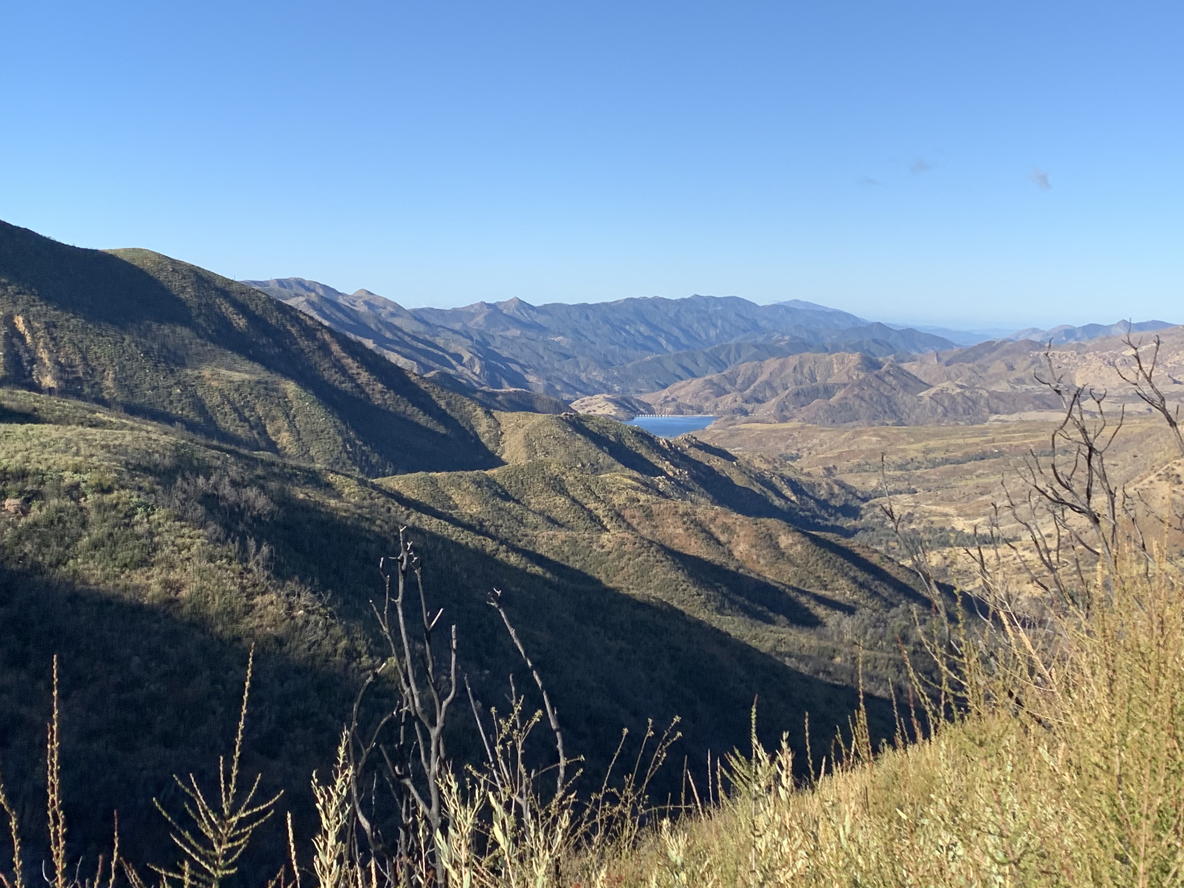
A short connector trail at the top of Murieta Divide. This trail climbs from Murieta Road 5N13.3 up to Divide Peak OHV Route also known as East Camino 5N12.1. Once you get to the top of the ridge you will have amazing views of Carpinteria, Santa Barbara, Ventura and the Channel Islands. You can access the trail from Matilija Trail head


 Monte Arido Trail Survey - 03-28-2026 - by Andy
| Link: | Monte Arido Trail |
| Date: | 03-28-2026 |
| Surveyor Name: | Andy |
| Trail description: | Trail looks recently brushed and easy to follow. I appreciate the earth works around the switchbacks, good job trail team! Note there is no water anywhere on this trail above the spring on the Murietta track further downhill. |
| Mode of transport: | Hike |
| Trail condition: | Good shape and easy to follow |
Monte Arido Trail Survey - 05-31-2024 - by Loren Butler | Link: | Monte Arido Trail |
| Date: | 05-31-2024 |
| Surveyor Name: | Loren Butler |
| Trail description: | Hiked the bike from Murrieta Divide up this in order to access Ocean View. Trail is currently in reasonable shape but, aside from the occasional bikepacker, I don't think it sees much traffic. Bit of a grind, but the views from the top and the extraordinary descent down Ocean View to the Ventura River make it entirely worthwhile. |
| Mode of transport: | Bicycle |
| Trail condition: | Needs some work |
| Condition details: | Trail is obvious but could use some work |
Monte Arido Trail Survey - 11-13-2023 - by Anonymous Surveyor| Link: | Monte Arido Trail |
| Date: | 11-13-2023 |
| Surveyor Name: | Anonymous Surveyor |
| Trail description: | I did not hike this trail so I am assuming it is in good shape. There is now a fancy post marking the top of the trail. I hiked the Ocean View Trail, which you can see on the map going a short way and stopping. It now goes all the way through and joins Kennedy Ridge Trail which goes all the way to the Ventura River in Ojai. The Ocean View Trial was in good shape and easy to follow. There is a kiosk near the junction with the OHV route and there are multiple picnic benches along the way. One of them may be named "White Ledge Camp" but it wasn't clear to me which one. One of them has multiple little tent pads carved into the scrub so that may be it. It's a difficult trail with no water on the trail. |
| Mode of transport: | Hike |
| Trail condition: | Good shape and easy to follow |
| Images: | Monte Arido sign at the top Kiosk near the beginning of Ocean View Trail |
Monte Arido Trail Survey - 01-09-2021 - by Stephen S| Link: | Monte Arido Trail |
| Date: | 01-09-2021 |
| Surveyor Name: | Stephen S |
| Trail description: | Hiked up Monte Arido Trail as part of a loop from Romero Saddle. Was surprised to see some snow still laying on the ground from the storm a couple weeks ago. Trail is easy enough to follow, some parts you just keep going uphill. Other recent hiker boot prints we helpful too. |
| Mode of transport: | Hike |
| Trail condition: | Needs some work |
Monte Arido Trail Survey - 04-12-2020 - by James| Link: | Monte Arido Trail |
| Date: | 04-12-2020 |
| Surveyor Name: | James |
| Trail description: | Needs some switchbacks, this bad boy is STEEP |
| Mode of transport: | Bicycle |
| Trail condition: | Needs some work |
| Condition details: | Overgrown, but easy to follow the general direction |
Monte Arido Trail Survey - 04-04-2020 - by Anonymous Surveyor| Link: | Monte Arido Trail |
| Date: | 04-04-2020 |
| Surveyor Name: | Anonymous Surveyor |
| Trail description: | The trail was in better condition than I thought it would be. Easy to follow after you locate the beginning that looks similar to a drainage ditch. A red bike was locked in the bushes. |
| Mode of transport: | Bicycle |
| Trail condition: | Needs some work |
Monte Arido Trail Survey - 12-15-2019 - by Christopher P. Lord| Link: | Monte Arido Trail |
| Date: | 12-15-2019 |
| Surveyor Name: | Christopher P. Lord |
| Trail description: | Travelled along Monte Arido on my way to White Ledge Peak. The trail is not easily discernible from the road and would benefit from a junction sign. While not in perfect condition for the most part it's relatively easy to follow. When in doubt just keep going straight up. A little brushing and some new switchbacks would go a long way here. To the West are some nice views of Jameson Lake and even more incredible ones await once atop the ridge. Coordinates mark the start of the trail with forest road 5N13 at the Divide:  N34° 29' 27.2" W119° 26' 11.2" For further details please see the link below. |
| Mode of transport: | Hike |
| Trail condition: | Needs some work |
| Images: | Monte Arido Junction Views of Jameson Lake From the ridge top looking back down Murietta Canyon Look back down on Forest Road 5N13 shortly after gaining the trail Incredible view from the top toward Divide Peak |
Monte Arido Trail Survey - 05-07-2019 - by Stephen S| Link: | Monte Arido Trail |
| Date: | 05-07-2019 |
| Surveyor Name: | Stephen S |
| Trail description: | Trail was difficult to spot from the road. Most of the trail was relatively straightforward to follow other than a few segments where going uphill seemed like the best bet since there was not really a discernible trail. Some really pretty sections of wildflowers. |
| Mode of transport: | Hike |
| Trail condition: | Needs some work |
| Images: | |
Monte Arido Trail Survey - 11-19-2016 - by Craig R. Carey| Link: | Monte Arido Trail |
| Date: | 11-19-2016 |
| Surveyor Name: | Craig R. Carey |
| Trail description: | Ascended the Monte Arido Trail with BSA Troop 111 on a recent service project. Steep, and recent fireline work during the Rey Fire has resulted in many of the old switchbacks being brushed in, so it's even steeper than usual (if you can imagine that). Great views once we hit the Ocean View OHV route! |
| Mode of transport: | Hike |
| Trail condition: | Good shape and easy to follow |
| Images: | |
Monte Arido Trail Survey - 06-11-2016 - by Anonymous Surveyor| Link: | Monte Arido Trail |
| Date: | 06-11-2016 |
| Surveyor Name: | Anonymous Surveyor |
| Trail description: | It is very easy to miss this trail. We hiked 1.25 miles past the turn off of Murietta Road, and started hiking along the headwaters of the Santa Ynez. Look left when you get to the top of Murietta Road. Stand on the bank to the left of the trail. You will see the trail snaking through the brush. |
| Mode of transport: | Hike |
| Trail condition: | Hard to follow |
| Condition details: | Passable but challenging. |
 Survey / Report Form - Please click this box to open the form.