 Use Marker Groups
 Wolf 2002
Piru 2003
Day 2006
Zaca 2007
Gap 2008
La Brea 2009

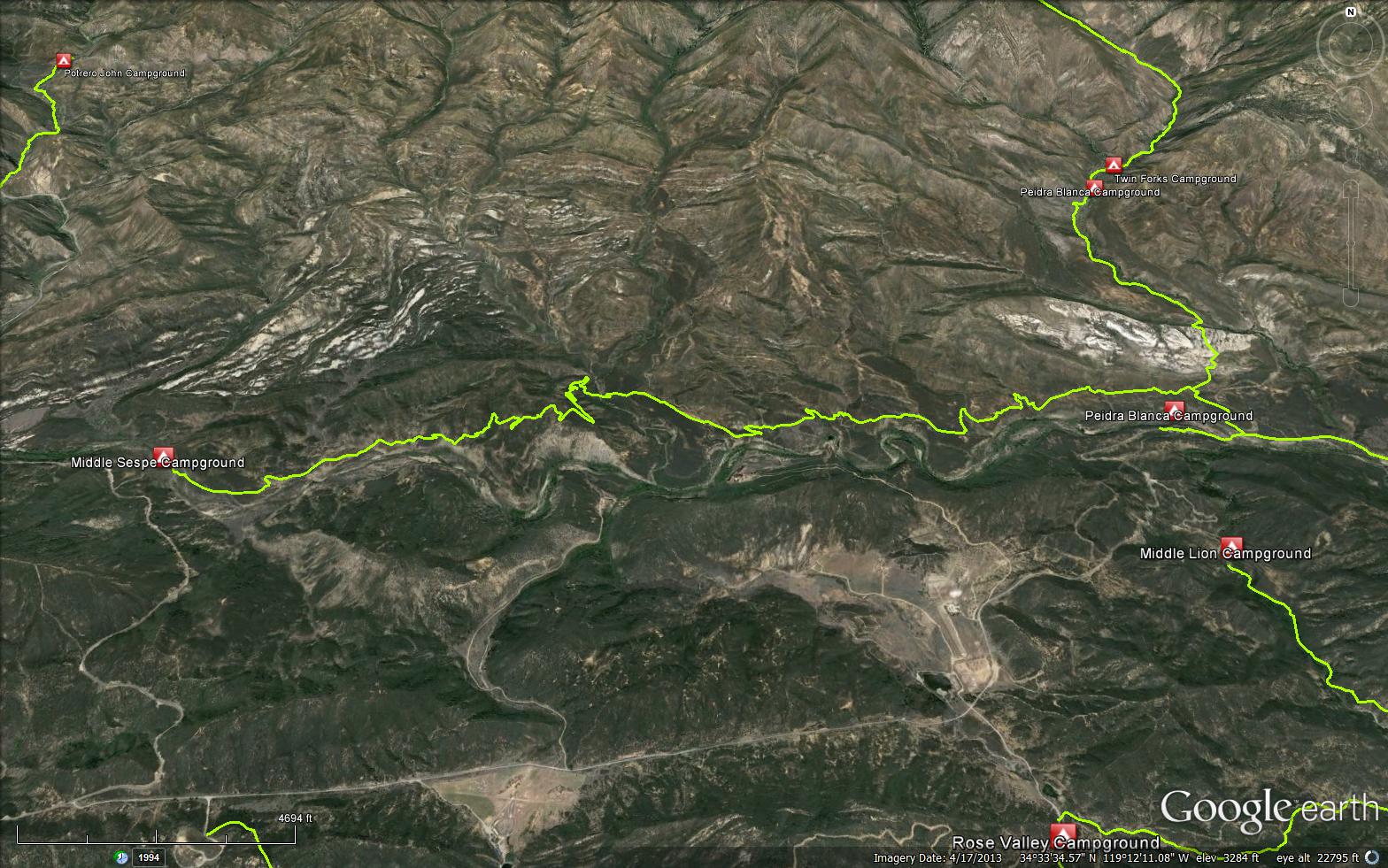
Drive to Middle Sespe Trailhead, 17.1 miles north of Ojai on Highway 33. The trailhead is on the right side of the highway . The trail crosses Sespe Creek and follows the old road. It then leaves the drainage and climbs over a steep bluff. Once you have reached the high point, you will drop down and cross Rock Creek. The trail parallels the Sespe until it joins the Gene Marshall-Piedra Blanca National Recreation Trail 22W03) . This junction is .8 miles from the Piedra Blanca trailhead.
The trail follows the north bank of Sespe Creek but climbs over a tall ridge to descend to and cross Rock Creek. It then passes on the north side of the river across from the old Herb Lathrop camp which later became the Circle B Ranch. At one time this ranch was a Boy Scout Camp but now is private property and called Rainbow Valley Ranch. Continuing down stream to a junction with the Gene Marshall National Recreation Trail then crossing the Sespe to end at Lion Camp. In the spring there is often good fishing in the Sespe between the mouth of Howard Creek and


 Middle Sespe Trail Survey - 06-06-2020 - by Anonymous Surveyor
| Link: | Middle Sespe Trail |
| Date: | 06-06-2020 |
| Surveyor Name: | Anonymous Surveyor |
| Trail description: | The trail started off well but became extremely steep and exposed before becoming completely overgrown. At one point it was completely gone and we ended up bushwhacking through dense brush before hitting the river. We were able to walk in the river to get back. We were ask very experienced hikers and this was not a trail I would do again without a lot of maintenance. |
| Mode of transport: | Hike |
| Trail condition: | Non existent |
| Condition details: | Trail needs work |
Middle Sespe Trail Survey - 12-15-2019 - by United Trail Maintainers of CA| Link: | Middle Sespe Trail |
| Date: | 12-15-2019 |
| Surveyor Name: | United Trail Maintainers of CA |
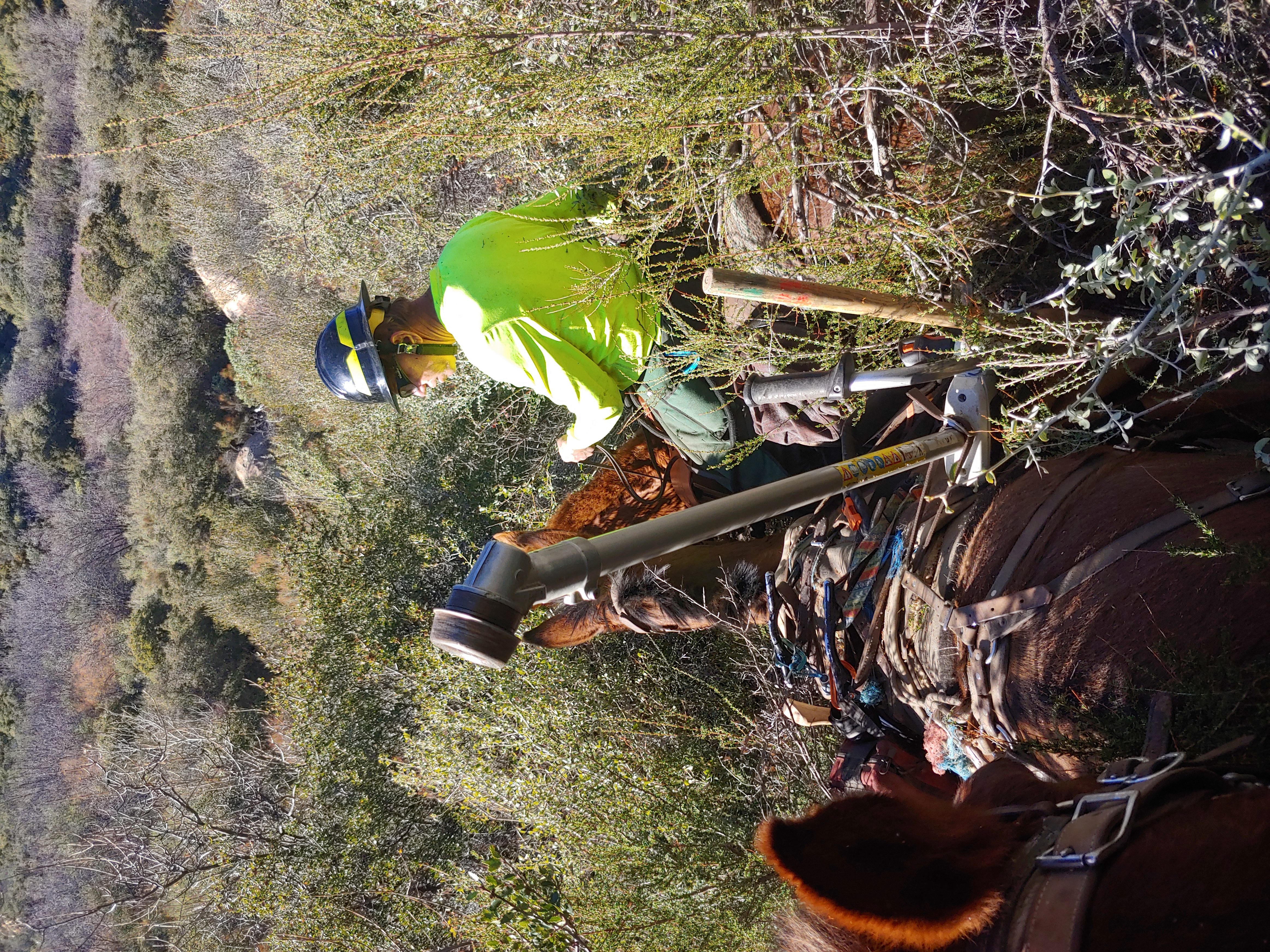
| Trail description: | Trail,is severely overgrown and completely closed over in many places. Walked ahead of stock in places and chainsawed just to get through to survey the Trailwork needed. This will be an extensive project taking more than one season to complete. Our first time seeing this trail. |
| Mode of transport: | Stock |
| Trail condition: | Hard to follow |
| Images: | |
Middle Sespe Trail Survey - 11-03-2019 - by Erin C| Link: | Middle Sespe Trail |
| Date: | 11-03-2019 |
| Surveyor Name: | Erin C |
| Trail description: | The Chamise has completely taken over on the east side of this trail. You used to be able to I can at least 2 miles before it got bad, now the whole inside is unpassable. LETS DO SOME TRAIL WORK on this trail soon before this is no longer a trail anymore!!!!!! |
| Mode of transport: | Hike |
| Trail condition: | Hard to follow |
| Images: | |
Middle Sespe Trail Survey - 05-27-2019 - by Louis Tremblay| Link: | Middle Sespe Trail |
| Date: | 05-27-2019 |
| Surveyor Name: | Louis Tremblay |
| Trail description: | Trail in need of work. Between Beaver peak and Rainbow Ranch the trail is washed out, extremely thick brush, at times head high poison oak. Add in the swarm of thicks in this area, and this is not a friendly trail. If attempting this don't wear shorts like I stupidly did. I honestly think if this was cleaned up and opened to bikes it would become a local favorite. On the upside, there was plenty of water in the creeks and beautiful views the whole way. |
| Mode of transport: | Hike |
| Trail condition: | Hard to follow |
| Condition details: | through-hiked, not for the faint |
Middle Sespe Trail Survey - 05-25-2018 - by Cairngorm| Link: | Middle Sespe Trail |
| Date: | 05-25-2018 |
| Surveyor Name: | Cairngorm |
| Trail description: | I
started at Beaver and went about 5.5 miles east. The trail is easy to
find now, marked most of the way by pink ribbon, orange ribbon and ducks. The way from the trailhead down to the creek is obvious. There was a good flow of water in the creek. Enjoy seeing it, because the trail goes inland and I never saw Sespe Creek
again. The next mile or so is an easy road. All the brush has been cleared
from the flat land north of
the road, leaving the area strewn with branches. Then it narrows to a
hiking trail, and as you climb easy switchbacks to the ridge at 3,750’,
the trail is single file in places, but completely passable. At one
place I missed a sharp left turn and found myself
following a short use trail that ended right after it crossed a dry creek. You
don’t need to do that. After the summit, things change. Going down there's a series of traverses across steep, loose hillside, which all
look almost unused, as if hardly anyone has risked it since the
winter. Along this stretch, the pink and orange
ribbons suddenly stop: the trail maintenance team must have been smarter than me and turned for home. They start again
lower down, I guess hung by a team coming from the other end. Rock Creek
was flowing well. After that the route got more overgrown, and I agree
with the last surveyor that heading down to Rainbow Ranch it becomes an
absolute gauntlet to run with scrub oak closed in almost the entire
way. Soon after that, the trail led me to one side of another steep, gravelly hillside where it looked like nobody had been foolhardy enough to cross this year at all,
and I suddenly looked at my watch and realized it was time to turn back to the car. |
| Mode of transport: | Hike |
| Trail condition: | Needs some work |
| Images: | |
Middle Sespe Trail Survey - 10-20-2017 - by Valerie Norton| Link: | Middle Sespe Trail |
| Date: | 10-20-2017 |
| Surveyor Name: | Valerie Norton |
| Trail description: | |
| Mode of transport: | Hike |
| Trail condition: | Needs some work |
| Condition details: | overgrown brush and some tread going missing |
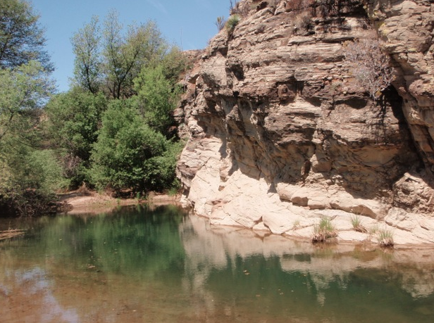
| Images: | Scrub oak closing in from one side near Rainbow Ranch. Around the corner, it gets to coming in from both sides and does not stop for more than 50 feet total over the next quarter mile. Trail in the creek bed. Hard to see, but you get cool patterns in the rocks. Trail down to Rock Creek. Got some nice rocks to show where it is. A slightly less slanted bit past that is trail. Then just look for the straighter break in the thin bushes. Easy, right? |
Middle Sespe Trail Survey - 11-24-2016 - by Jay Rock| Link: | Middle Sespe Trail |
| Date: | 11-24-2016 |
| Surveyor Name: | Jay Rock |
| Trail description: | Thanksgiving Day 2016 I stared at the interior Trail Head and walked it out and back. Having never been here before it was a bit confusing to find.  From the parking lot you'll start a trail and start down into the valley, you'll cross over the creek bed (dry as of this writing) and pick up the trail on the other side.  You'll ascend and wind around a bit but you'll come to the conjunction of the trials as marked with a wooden sign. see below. The trail is more or less flat through the middle with good footing about 97% of the way. 50 degrees but no shade, I imagine it's a killer hot trail during the summer. This time of the year, there is ice in the shade at the bottom of valleys and it was very chilly. Trail varies in width from almost 6ft wide to single file. Low brush, some signs of deer, but mostly birds with a few scattered lizards. |
| Mode of transport: | Hike |
| Trail condition: | Good shape and easy to follow |
| Images: | Walk on the way from parking lot - very cold in the shade, frozen mud and ice in ditches. Trail Head - Middle sespe seems like it's lightly used, I didn't see anybody on it, but it was only one day. Looking back towards parking lot. you can make out the road on the top/middle right as it cut backs and descends into the trees. Parking lot would be behind trees on left. Example of trail straight aways, note lack of shade. Straight aways are bookended by cutbacks that snake around dry feeder stream beds. |
Middle Sespe Trail Survey - 05-29-2016 - by Ritz| Link: | Middle Sespe Trail |
| Date: | 05-29-2016 |
| Surveyor Name: | Ritz |
| Mode of transport: | Hike |
| Trail condition: | Hard to follow |
| Condition details: | Lots of bush whacking needed. Can be very difficult to find trail. |
Middle Sespe Trail Survey - 07-26-2015 - by Donna Spencer| Link: | Middle Sespe Trail |
| Date: | 07-26-2015 |
| Surveyor Name: | Donna Spencer |
| Trail description: |     Well here we go again, off on another beautiful hike when the dreaded monster of plants take charge. I was enjoying the expansive views when I dropped into Rainbow Valley and the sage brush plant obscured the trail. Then when climbing through a knoll, jest before the only major climb, ran into 6' to 7' overgrowth of plants. So I turned around and went back to the Sespe Trail Head at Rose Valley.  However I will make another trip and try this hike from Highway 33. Overall this was a beautiful hike, I am just threating to bring a battery powered hedger and take care of business. |
| Mode of transport: | Hike |
| Trail condition: | Needs some work |
| Condition details: | Just passed Rainbow Valley 6' to 7' tall plants overgrown on the trail (at the knoll). |
Middle Sespe Trail Survey - 05-13-2014 - by Los Padres Forest Association| Link: | Middle Sespe Trail |
| Date: | 05-13-2014 |
| Surveyor Name: | Los Padres Forest Association |
| Trail description: | Trail was in good shape with no issues to report. Water was flowing nicely along the Sespe. |
| Mode of transport: | Hike |
| Trail condition: | Good shape and easy to follow |
| People Seen: | 0 |
| Images: | |
 Survey / Report Form - Please click this box to open the form.