 Use Marker Groups
 Wolf 2002
Piru 2003
Day 2006
Zaca 2007
Gap 2008
La Brea 2009

The creek is named for Jeff Howard who came to the area in 1875 and established a mountain cattle ranch in 1877. Jeff shot and killed a Basque sheep herder who had run his sheep on Jeff's pasture on Rock Creek. Sentenced to prison, he escaped and fled to Arizona. He was returned to Ojai and then once again escaped and never was captured again. He died near Prescott Arizona in 1910 at the age of 92 years.
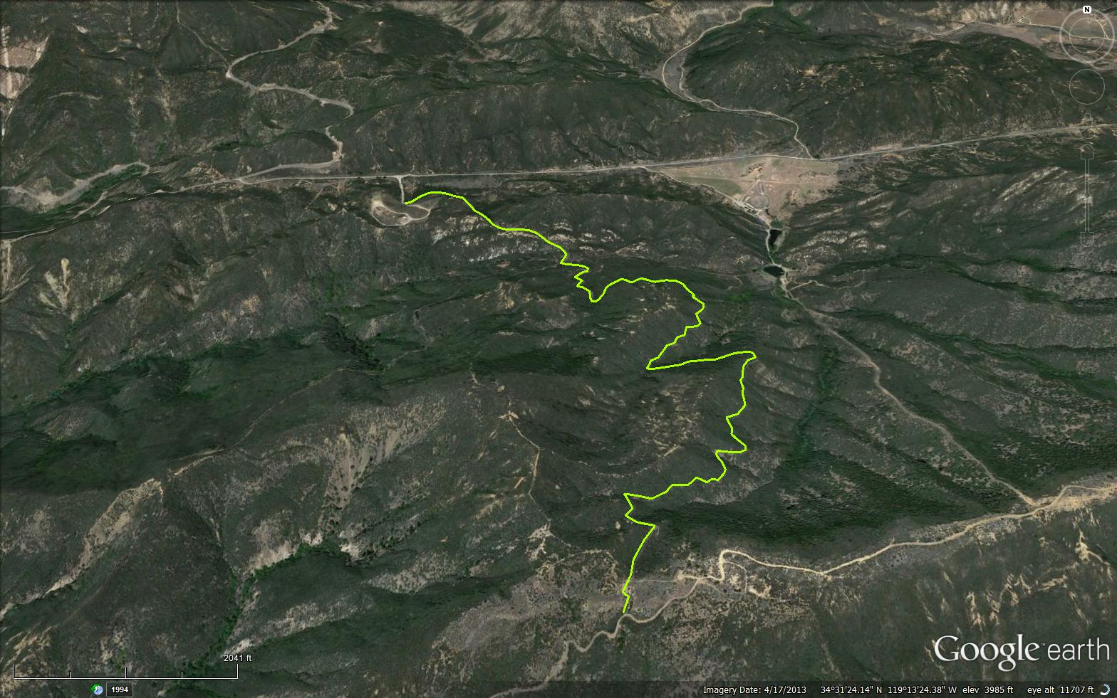
This steep trail starts on the south side of the road from Highway 33 to Rose Valley just west on private property named Rancho Grande on upper Howard Creek. The trail climbs up to join the Rose Valley Road to Nordhoff Ridge Road. It is a northern route to reach Nordhoff Peak. A part of the trail was constructed by a U. S. Navy Construction Battalion commonly known as Seabees who had a training base located at Rose Valley. As part of their training they built numerous roads, trails and the Rose Valley Iakes.
Turn right on Rose Valley Road and drive .4 miles and park on the right. The trail starts on a dirt road behind a locked gate. This is one of the shortest hikes to Nordhoff Ridge where there are fantastic views of the coastline and the Ojai Valley.


 Howard Creek Trail Survey - 02-23-2024 - by bardley
| Link: | Howard Creek Trail |
| Date: | 02-23-2024 |
| Surveyor Name: | bardley |
| Trail description: | the previous trail report describing down limbs causing hindrance to navigation is hereby amended. all three, plus two additional, down tree trunks / limbs have been removed. there are no more obstructions on this trail. rosemary "rosie" sepulveda, trails specialist from the usfs ojai ranger district, led the project to remove them. also, the notorious inside corner has actually improved with the latest rain event, although cyclists will still need to carry their transport over this area. the shortest, most direct means of gaining access to nordhoff ridge, is open for business. still needs some brushing and be aware of the dormant poodle dog bush. |
| Mode of transport: | Hike |
| Trail condition: | Needs some work |
| Condition details: | rosie and bardley get it done, uh-huh |
Howard Creek Trail Survey - 01-31-2024 - by bardley| Link: | Howard Creek Trail |
| Date: | 01-31-2024 |
| Surveyor Name: | bardley |
| Trail description: | Howard Creek Trail is open to foot traffic. There are three fallen limbs that present a challenge to bicycles and a full stop to stock. Brushing is called for in certain areas but the overgrown vegetation does not preclude transit. The at-times treacherous inside corner is passable with care. This report is being generated after the rain events of 2/3-4-5 of 2024 wherein highway 33 was closed by CalTrans. so a more current report will be needed when the road is reopened. Howard Camp, a car camp on Nordhoff Ridge, is a short use trail away from this trail. It has a fire ring, picnic table, a hitching bar for several stock and a single post for unruly stock. It is open and unsheltered on the ridge but sheltering space surrounds the camp for bags and tents. |
| Mode of transport: | Hike |
| Trail condition: | Needs some work |
| Condition details: | Open to foot traffic, bicycles / stock beware |
Howard Creek Trail Survey - 12-17-2022 - by Charlie Murphy| Link: | Howard Creek Trail |
| Date: | 12-17-2022 |
| Surveyor Name: | Charlie Murphy |
| Trail description: | Overall the trail is passable, but it does get brushy in some sections, and the small streams that cross the trail are causing erosion issues. It would probably take 1 day for a 5-6 person trail crew to get this trail back to a more flowy condition. So spectacular to see all the small streams flowing with snow melt water right now! |
| Mode of transport: | Bicycle |
| Trail condition: | Needs some work |
| Images: | |
Howard Creek Trail Survey - 03-08-2022 - by bardley| Link: | Howard Creek Trail |
| Date: | 03-08-2022 |
| Surveyor Name: | bardley |
| Trail description: | There is no water along this trail. It is free of obstruction from end to end. It is the shortest route to Nordhoff Ridge and all of the views that has to offer. Bonus is the picnic table at Howard Creek Camp at the top! Be mindful of the poodle dog bush - https://en.wikipedia.org/wiki/Eriodictyon_parryi - along the way. It is currently semi-dormant. Some green leaves but a lot of brown. It can still getcha. Like poison oak - only worse. |
| Mode of transport: | Hike |
| Trail condition: | Good shape and easy to follow |
Howard Creek Trail Survey - 03-14-2021 - by bardley| Link: | Howard Creek Trail |
| Date: | 03-14-2021 |
| Surveyor Name: | bardley |
| Trail description: | Sure, like most trails, the Howard Creek Trail could use some brushing in a few places. And there are a few places where side drainages have deposited rock debris which could use some cautious traverse and minor shoveling. Not to leave out the persistent poodle dog some of which is dormant, others appears quite healthy and vibrant - mostly found on the upper reaches on the north-facing shaded track. All plants are easily avoidable. But for a short, sweet hike to Nordhoff Ridge - this is it. No route finding involved. With a picnic table at the top at Howard Creek Camp. What more could and outdoorsperson want? |
| Mode of transport: | Hike |
| Trail condition: | Good shape and easy to follow |
Howard Creek Trail Survey - 07-03-2020 - by bardley| Link: | Howard Creek Trail |
| Date: | 07-03-2020 |
| Surveyor Name: | bardley |
| Trail description: | Needs brushing. Be mindful of tread. Side drainages need work. Easy to follow. Shortest, fastest route to Nordhoff Ridge. Although there is no reliable water along this trail there is a small gurgling seep in the lower section. |
| Mode of transport: | Hike |
| Trail condition: | Needs some work |
| Condition details: | Brushy, some poison oak, poodle dog |
Howard Creek Trail Survey - 09-12-2019 - by RJ Wean| Link: | Howard Creek Trail |
| Date: | 09-12-2019 |
| Surveyor Name: | RJ Wean |
| Trail description: | Rose Valley Trail head to ridge. trail is in fair to good condition. There are a couple of badly washed out spots and some spots where the hillside above is sliding down making for some narrow sections.Poodle Dog is present along side of the trail in spots but none is blocking the trail. Manzanita is coming back and hopefully will soon crowd out the Poodle Dog! |
| Mode of transport: | Hike |
| Trail condition: | Needs some work |
Howard Creek Trail Survey - 06-15-2019 - by Anonymous Surveyor| Link: | Howard Creek Trail |
| Date: | 06-15-2019 |
| Surveyor Name: | Anonymous Surveyor |
| Trail description: | Was recommended the Howard Creek trail by a ranger at the Wheeler Gorge visitor center who failed to mention (or didn't know) that there was Poodle Dog Bush growing all along the trail. It's a beautiful purple flower that's more poisonous than poison oak. Beware of this trail because there are fields of them along the trail giving hikers no choice but to walk through them. Called the visitor center to let them know some of our hikers were already developing rashes and hopefully they'll send someone out to get rid of them before anyone else hikes it. |
| Mode of transport: | Hike |
| Trail condition: | Needs some work |
| Condition details: | Warning:Possible poodle dog Bush growth along trail |
| Images: | Possible poodle dog Bush growing along trail |
Howard Creek Trail Survey - 03-25-2019 - by Jim Kenney| Link: | Howard Creek Trail |
| Date: | 03-25-2019 |
| Surveyor Name: | Jim Kenney |
| Trail description: | Overall the trail is in good shape. There are a few washouts that could use some attending. Some more urgent than others. I have documented the locations of the washouts in the following pictures.  |
| Mode of transport: | Hike |
| Trail condition: | Needs some work |
| Condition details: | Howard Creek to the Ridge |
| Images: | 34.5237, -119.21929 34.52278,-119.21997 34.52024, -119.21759 34.5178, -119.219 34.53252, -119.23051 |
Howard Creek Trail Survey - 09-08-2018 - by Los Padres Forest Association| Link: | Howard Creek Trail |
| Date: | 09-08-2018 |
| Surveyor Name: | Los Padres Forest Association |
| Trail description: | Trail survey of Howard Creek Trail from September 8, 2018: https://arcg.is/1DLDiH |
| Mode of transport: | Hike |
| Trail condition: | Needs some work |
Howard Creek Trail Survey - 07-07-2018 - by Don Jackson| Link: | Howard Creek Trail |
| Date: | 07-07-2018 |
| Surveyor Name: | Don Jackson |
| Trail description: | This was a post-Thomas fire trail survey that found the tread in very poor condition. This was obviously the result of the fire and the January rains. The primary result were three large areas of the trail that where material (scree, sand, soil) from the upslope had flowed over the trail....leaving no tread. The trail can be hiked, but with great caution. |
| Mode of transport: | Hike |
| Trail condition: | Needs some work |
| Condition details: | Needs a lot of tread work to repair the sluff coming from upslope in three areas, and the large rut near burned pines. |
| Images: | Howard Creek Trail - post-Thomas fire Largest area in need of tread repair Detail of largest area in need of tread repair Second tread repair area Third tread repair area |
Howard Creek Trail Survey - 11-10-2017 - by Valerie Norton| Link: | Howard Creek Trail |
| Date: | 11-10-2017 |
| Surveyor Name: | Valerie Norton |
| Trail description: | Ventura Sierra Club was out to climb from Rose Valley to the ridge then back down along the trail and I tagged along. Minor sluff from above getting onto the trail and blush is very close, but off on the side. It will probably need brushing and that sluff removed in a year or two, but for now very comfortable coming down. |
| Mode of transport: | Hike |
| Trail condition: | Good shape and easy to follow |
Howard Creek Trail Survey - 04-06-2017 - by bardley| Link: | Howard Creek Trail |
| Date: | 04-06-2017 |
| Surveyor Name: | bardley |
| Trail description: |
Several trail-blocking limbs were discovered on the trail during the survey and were removed. Overall the tread is in good condition and minimal brushing is needed. There is an approximate 100 yard long section where recent storms and inadequate water diversions created a one-foot (1') to three-foot (3') deep trench in the middle of the trail. This section presents a hazard to passage of foot, stock and wheeled travelers. There is also sloughing and some topping of the crib walls from up-slope soil further along the trail. |
| Mode of transport: | Hike |
| Trail condition: | Needs some work |
| Condition details: | needs tread work |
| Images: | rut rut northern trailhead |
Howard Creek Trail Survey - 10-08-2016 - by Katie| Link: | Howard Creek Trail |
| Date: | 10-08-2016 |
| Surveyor Name: | Katie |
| Mode of transport: | Hike |
| Trail condition: | Good shape and easy to follow |
| Images: | |
Howard Creek Trail Survey - 02-16-2016 - by Geoff | Link: | Howard Creek Trail |
| Date: | 02-16-2016 |
| Surveyor Name: | Geoff |
| Trail description: | Great trial wonderful views from the ridge Mostly shaded but no water Ensure  you look for trial on the left about .5 miles from parking on the road fire road.  We  missed it initially |
| Mode of transport: | Hike |
| Trail condition: | Good shape and easy to follow |
Howard Creek Trail Survey - 12-12-2015 - by Los Padres Forest Association| Link: | Howard Creek Trail |
| Date: | 12-12-2015 |
| Surveyor Name: | Los Padres Forest Association |
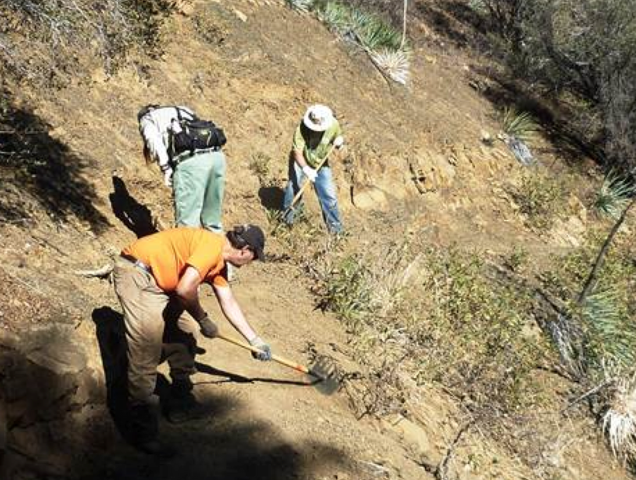
| Trail description: | The Ojai Ranger District led a trail project along the Howard Creek trail on December 12, 2015. Â They worked starting from 1/2 mile up the trail towards the top. Â There are plans to complete the first 1/2 mile at a later date. |
| Mode of transport: | Array |
| Trail condition: | Good shape and easy to follow |
| Images: | Photo Ranger Heidi |
Howard Creek Trail Survey - 05-23-2015 - by Dan Whelan| Link: | Howard Creek Trail |
| Date: | 05-23-2015 |
| Surveyor Name: | Dan Whelan |
| Trail description: | Trail is in great shape. There are some spots where the annual grasses and plant have closed the trail in but still very easy to follow and pass. No water on trail |
| Mode of transport: | Hike |
| Trail condition: | Good shape and easy to follow |
 Survey / Report Form - Please click this box to open the form.