Welcome To Hike Los Padres!
User Log In or Sign Up
Use Marker Cluster
Markers: Use Marker Groups
Time used: ms
Routes
    Trails
    OHV Trails
    Forest Roads
    Streams
Wildfire Layers
    Wolf 2002
    Piru 2003
    Day 2006
    Zaca 2007
    Gap 2008
    La Brea 2009
Forest Layers
    Forest Boundary
    Wilderness Areas
    Ranger Districts
    Counties
    Topographic Outlines
    Trailheads
    OHV Trailheads
Helpful Hints
    ↣ Right click the map for location data. ↣ Click a stream for Water Stats.

Horseshoe Springs Spur OHV Trail - Los Padres National Forest
Trail Distance .82 Miles

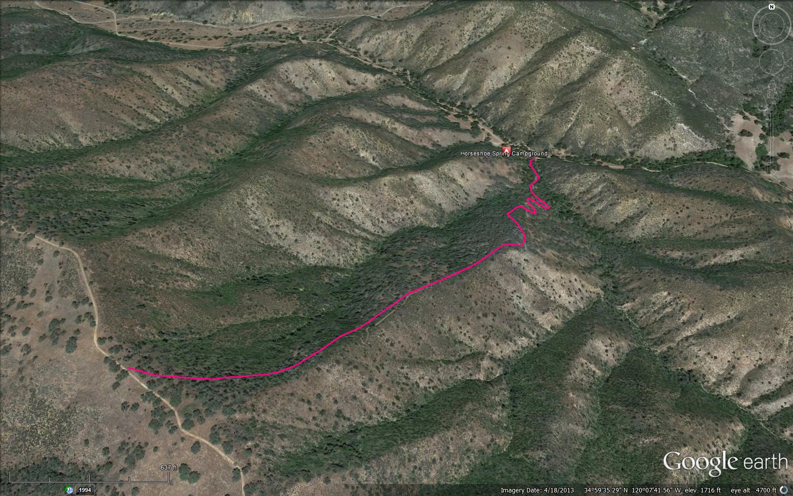
This route begins at Horseshoe Campground and intersects the Buckhorn Ridge route. This is a good trail for intermediate motorcycle riders.

Trail Details

  • Trail #: 31W12
  • Wilderness Area: Non Wilderness Area
  • County: Santa Barbara County
  • Ranger District: Santa Lucia Ranger District
  • Trail-head Latitude: 34.99696
  • Trail-head Longitude: -120.12436
  • Trail Condition: Good
  • Topo Maps:
  • Activities & Features:
    • Mountain Biking
    • OHV Area


Trail Stats

  • Total Elevation Gain: + 1129 feet.
  • Total Elevation Loss: - 108 feet.
  • Overall Average Slope Gain: + 24 %.
  • Overall Average Slope Loss: - 6 %.
  • Kilometers: (km)
  • Meters: (m)
  • Miles: (mi)
  • Feet: (ft)
  • Average Slope: (%)
Upload Images Aerial Overview Image Login to Download GPS File
Survey This Trail

Survey Photos:


  • Los Padres Forest Association - 05-03-2020

  • Los Padres Forest Association - 05-03-2020

Submitted Trail Reports

Horseshoe Springs Spur OHV Trail Survey - 05-03-2020 - by Los Padres Forest Association
Link: Horseshoe Springs Spur OHV Trail
Date: 05-03-2020
Surveyor Name:Los Padres Forest Association
Trail description:Did not take the trail but the trailhead at both ends were marked and easy to see.  The sign at the upper trailhead along Buckhorn Ridge is off the post and resting on the ground.  The trail looks overgrown with both grass as well as brush and would need to be worked before being a good motorcycle ride.
Mode of transport:Array
Trail condition:Hard to follow
Images:

Lower trailhead, just above Horseshoe Spring Campground

Upper trailhead along the Buckhorn Ridge Road


Leave A Trail Report

Survey / Report Form - Please click this box to open the form.


Last Updated: Wednesday, March 30, 2016


Join Mailing List
×
Get updates on conditions, surveys and more...


Current Weather »


L.P.N.F. Contacts »

  • Forest Headquarters
    Phone: (805) 968-6640
  • Mt. Pinos District
    Phone: (661) 245-3731
  • Ojai Ranger District
    Phone: (805) 646-4348
  • Santa Barbara District
    Phone: (805) 967-3481
  • Santa Lucia District
    Phone: (805) 925-9538
  • Monterey District
    Phone: (831) 385-5434