 Use Marker Groups
 Wolf 2002
Piru 2003
Day 2006
Zaca 2007
Gap 2008
La Brea 2009

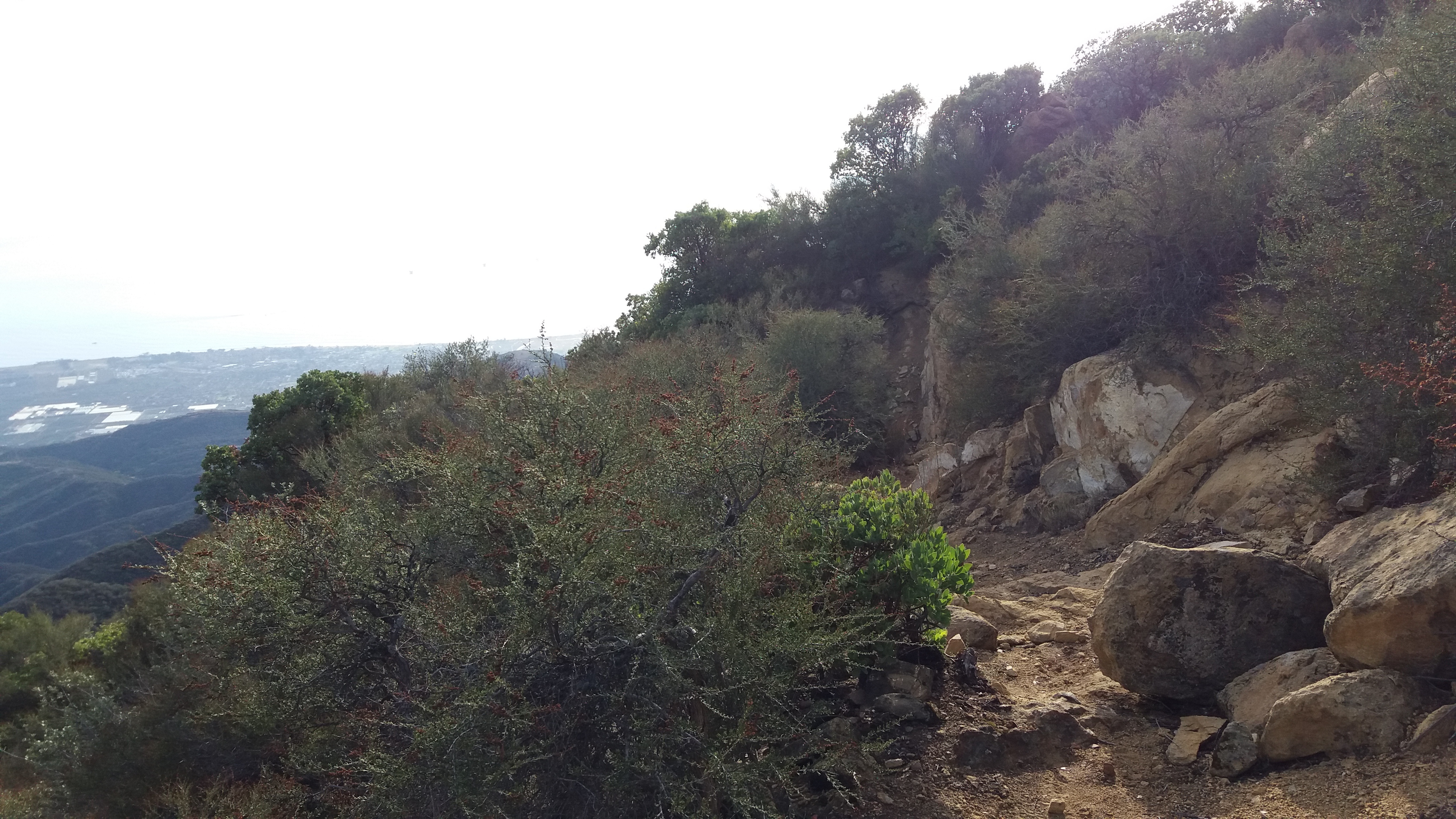
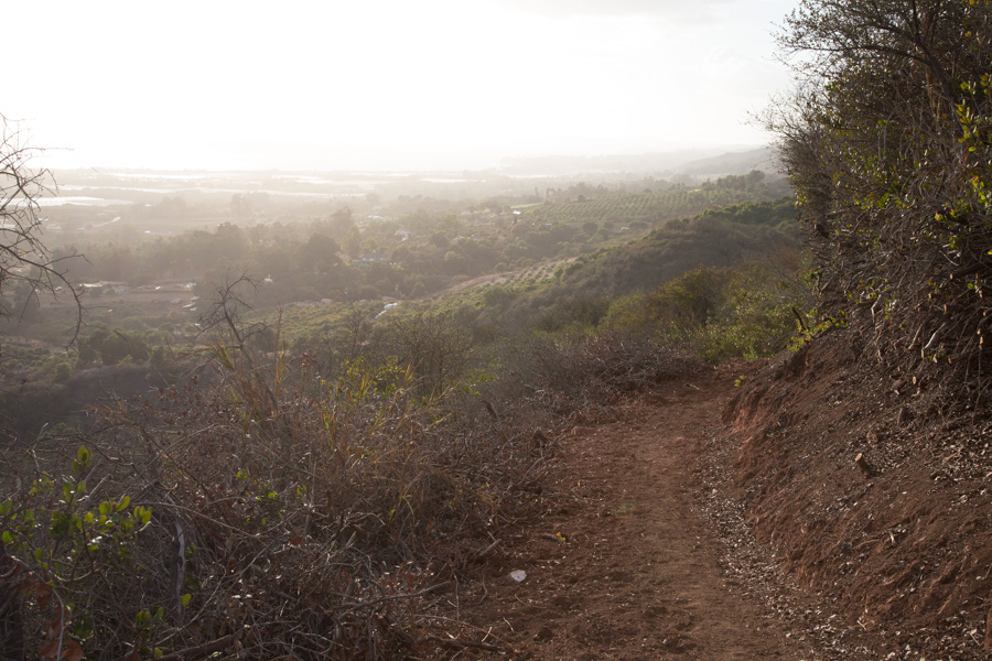
Though not open for more than 30 years, thanks to the efforts of the Friends of the Franklin Trail, the part of the historic route to the crest is now accessible to the public. The trail takes you past Carpinteria High School and then climbs 600 feet to the top of a prominent knoll. Along with the ascent, the views get better and better. There is a beautiful wood carved bench at the top where you can enjoy the best viewing spot in the area. The trail then proceeds up the dirt road to a locked gate (2.2 miles from the start), then pass this gate and head up the road following the trail markers to the upper portion of the trail for 3 miles, the trail then starts and climbs towards the crest and Divide Peak OHV route. The upper portion of the trail is 1.8 miles long and the most beautiful portion of the trail.
The Franklin Trail provided access for decades for many an outdoor adventurer, hunter, fisherman and backcountry explorer for many decades until things began to change after World War II, especially as avocado ranching became more and more prominent. About the same time Carpinterians were first venturing over the Santa Ynez Mountains to explore the mysteries of the backcountry, Santa Barbara Judge R.B. Ord introduced the Mexican avocado to the area. By the 1950s a number of varieties were becoming commercially successful, among them the Fuerte and the Hass.

In Carpinteria, ranches such as those owned by the Franklin families and others began to change hands and this shift in ownership accelerated in the early 1970s when the Carpinteria Valley became a mecca for commercial flower growing. Over time a wide swath of valley land stretching along the base of the mountains from Santa Monica Canyon east to the County were developed either for avocados or nursery related businesses. By the mid 70s public access to the mountains ground to a halt and after the Romero Fire in 1971, brush rapidly closed in what was left of the upper parts of the Franklin Trail.


 Franklin Trail South Survey - 04-01-2022 - by Adam Donald
| Link: | Franklin Trail South |
| Date: | 04-01-2022 |
| Surveyor Name: | Adam Donald |
| Trail description: | The trail is heavily traveled and clear up until the start of the upper singletrack. Some deep gullies in the road that would make utility/fire/farm vehicle access a bit sketchy at one steep grade. No water flowing where the creek crosses the road. Vegetation has grown in quite a bit in the lower portion of the singletrack, but the trail is easy to follow all the way to the crest. Watch for ticks when pushing through brush. Soooo many wildflowers in bloom this time of year after the rain. |
| Mode of transport: | Hike |
| Trail condition: | Good shape and easy to follow |
| Images: | |
Franklin Trail South Survey - 01-01-2020 - by Jasonn Beckstrand| Link: | Franklin Trail South |
| Date: | 01-01-2020 |
| Surveyor Name: | Jasonn Beckstrand |
| Trail description: | Trail is in great shape all the way to the top of the mountain. The LPFA trail crew has worked the last section and it looks great. |
| Mode of transport: | Hike |
| Trail condition: | Good shape and easy to follow |
| Images: | switchbacks up the mountain views from the trail. |
Franklin Trail South Survey - 02-23-2018 - by Los Padres Forest Association| Link: | Franklin Trail South |
| Date: | 02-23-2018 |
| Surveyor Name: | Los Padres Forest Association |
| Trail description: | BAER trail assessment: - North side only - Trail not hard to follow but lots of work needed to repair - Flume was damaged in the fire and knocked out in the 1/9 debris flows - Trail passable with some downed trees |
| Mode of transport: | Hike |
| Trail condition: | Needs some work |
| Images: | That's the trail That's also the trail Flume destroyed by the Thomas Fire and 1/9/18 debris flows |
Franklin Trail South Survey - 07-06-2017 - by La Foote| Link: | Franklin Trail South |
| Date: | 07-06-2017 |
| Surveyor Name: | La Foote |
| Trail description: | Finally hiked phase 3 today and it is absolutely wonderful! Â Wide and clean, some lingering wildflowers still hanging on. We started at 7am, so had adequate shade all the way up to the top. It took us roughly 3 hours from Carp High to the DP road. We then tacked on another 4.5 miles and did FT North to Jameson and back. Glad to get back on FT south and let gravity help us home. Long, hot, gruel-tastic hike. Our (my) pace was slow due to the heat and gains. Total time 5 hours each way from Carp High to Jameson, but well worth it. Â |
| Mode of transport: | Hike |
| Trail condition: | Good shape and easy to follow |
Franklin Trail South Survey - 05-04-2017 - by Los Padres Forest Association| Link: | Franklin Trail South |
| Date: | 05-04-2017 |
| Surveyor Name: | Los Padres Forest Association |
| Trail description: | Recent Noozhawk article by Ray Ford talking about the history of the Franklin Trail and current status of the trail. Â If you've not hiked Phase III, now is the time! Â Just bring a lot of water...... https://www.noozhawk.com/article/reopening_the_historic_franklin_trail |
| Mode of transport: | Array |
| Trail condition: | Good shape and easy to follow |
Franklin Trail South Survey - 05-13-2015 - by Gerry Ching| Link: | Franklin Trail South |
| Date: | 05-13-2015 |
| Surveyor Name: | Gerry Ching |
| Trail description: | Phase 2 of the trail just opened to the public. The Phase 2 route is entirely on a dirt fire road. Great views of Carpinteria for most of the distance. Total distance (Phases 1 & 2) is now 5.2 miles. Total elevation gain is about 1700 feet but since the route dips down into minor and moderate canyons, cumulative elevation gain is about 2300 ft. Be sure to allow enough time (about 6 hrs) to do the round trip with a lunch stop. There is a nice bench and lookout at the 3.2 mile point, |
| Mode of transport: | Hike |
| Trail condition: | Good shape and easy to follow |
Franklin Trail South Survey - 02-02-2014 - by Gordon Jenkins| Link: | Franklin Trail South |
| Date: | 02-02-2014 |
| Surveyor Name: | Gordon Jenkins |
| Trail description: | |
| Mode of transport: | Hike |
| Trail condition: | Non existent |
| Condition details: | First day of trail work with Ray Ford, upper Franklin trail. |
 Survey / Report Form - Please click this box to open the form.