Welcome To Hike Los Padres!
User Log In or Sign Up
Use Marker Cluster
Markers: Use Marker Groups
Time used: ms
Routes
    Trails
    OHV Trails
    Forest Roads
    Streams
Wildfire Layers
    Wolf 2002
    Piru 2003
    Day 2006
    Zaca 2007
    Gap 2008
    La Brea 2009
Forest Layers
    Forest Boundary
    Wilderness Areas
    Ranger Districts
    Counties
    Topographic Outlines
    Trailheads
    OHV Trailheads
Helpful Hints
    ↣ Right click the map for location data. ↣ Click a stream for Water Stats.

Carmel River Trail - Los Padres National Forest
Trail Distance 13.20 Miles

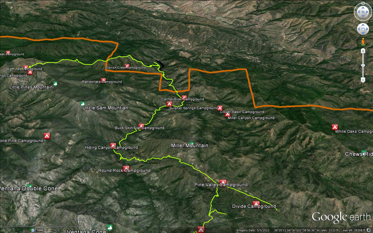
A 13 mile long trail in the Ventana Wilderness that starts at the Los Padres Dam and ends at the Pine Ridge Trail (3E06).

Trail Details

  • Trail #: 3E03
  • Wilderness Area: Ventana
  • County: Monterey County
  • Ranger District: Monterey Ranger District
  • Trail-head Latitude: 36.38405
  • Trail-head Longitude: -121.67138
  • Water Sources: Available
  • Trail Condition: Kind of Good - Little to no bushwacking and easily followable
  • Topo Maps:
  • Activities & Features:
    • Backpacking
    • Creek
    • Day Hiking
    • River
    • Wildlife Viewing
    • Wilderness Camping


Trail Stats

  • Total Elevation Gain: + 1403 feet.
  • Total Elevation Loss: - 3974 feet.
  • Overall Average Slope Gain: + 9 %.
  • Overall Average Slope Loss: - 11 %.
  • Kilometers: (km)
  • Meters: (m)
  • Miles: (mi)
  • Feet: (ft)
  • Average Slope: (%)

Trail Camps

Upload Images Aerial Overview Image Login to Download GPS File
Survey This Trail

Submitted Trail Reports

Carmel River Trail Survey - 02-20-2021 - by Anonymous Surveyor
Link: Carmel River Trail
Date: 02-20-2021
Surveyor Name:Anonymous Surveyor
Trail description:From the north:  There are a couple of blazed trails to go up and over the mudslide that washed into the western side of Los Padres Reservoir.  Head around the west side of the lake across the dam, and where there is a large fallen tree across the wide path heading up to the mudslide, you will see a bushwacked trail switchbacking up the hill on the right hand side.  Follow that up and over the mudslide - adds probably a couple hundred feet of very steep elevation gain.  Poles recommended.  Then you can regain the Carmel River trail which is still fairly intact.  You will have to ford Danish Creek, and the trail is slightly harder to find on the other side of it, and slightly overgrown but still definitely passable, all the way to Carmel River camp.
Mode of transport:Hike
Trail condition:Needs some work
Condition details:New trail around the mudslide


Leave A Trail Report

Survey / Report Form - Please click this box to open the form.


Last Updated: Monday, February 15, 2016


Join Mailing List
×
Get updates on conditions, surveys and more...


Current Weather »


L.P.N.F. Contacts »

  • Forest Headquarters
    Phone: (805) 968-6640
  • Mt. Pinos District
    Phone: (661) 245-3731
  • Ojai Ranger District
    Phone: (805) 646-4348
  • Santa Barbara District
    Phone: (805) 967-3481
  • Santa Lucia District
    Phone: (805) 925-9538
  • Monterey District
    Phone: (831) 385-5434