 Use Marker Groups
 Wolf 2002
Piru 2003
Day 2006
Zaca 2007
Gap 2008
La Brea 2009

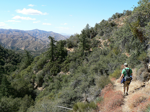
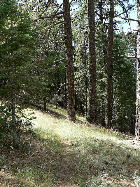
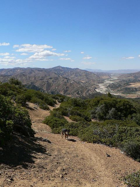
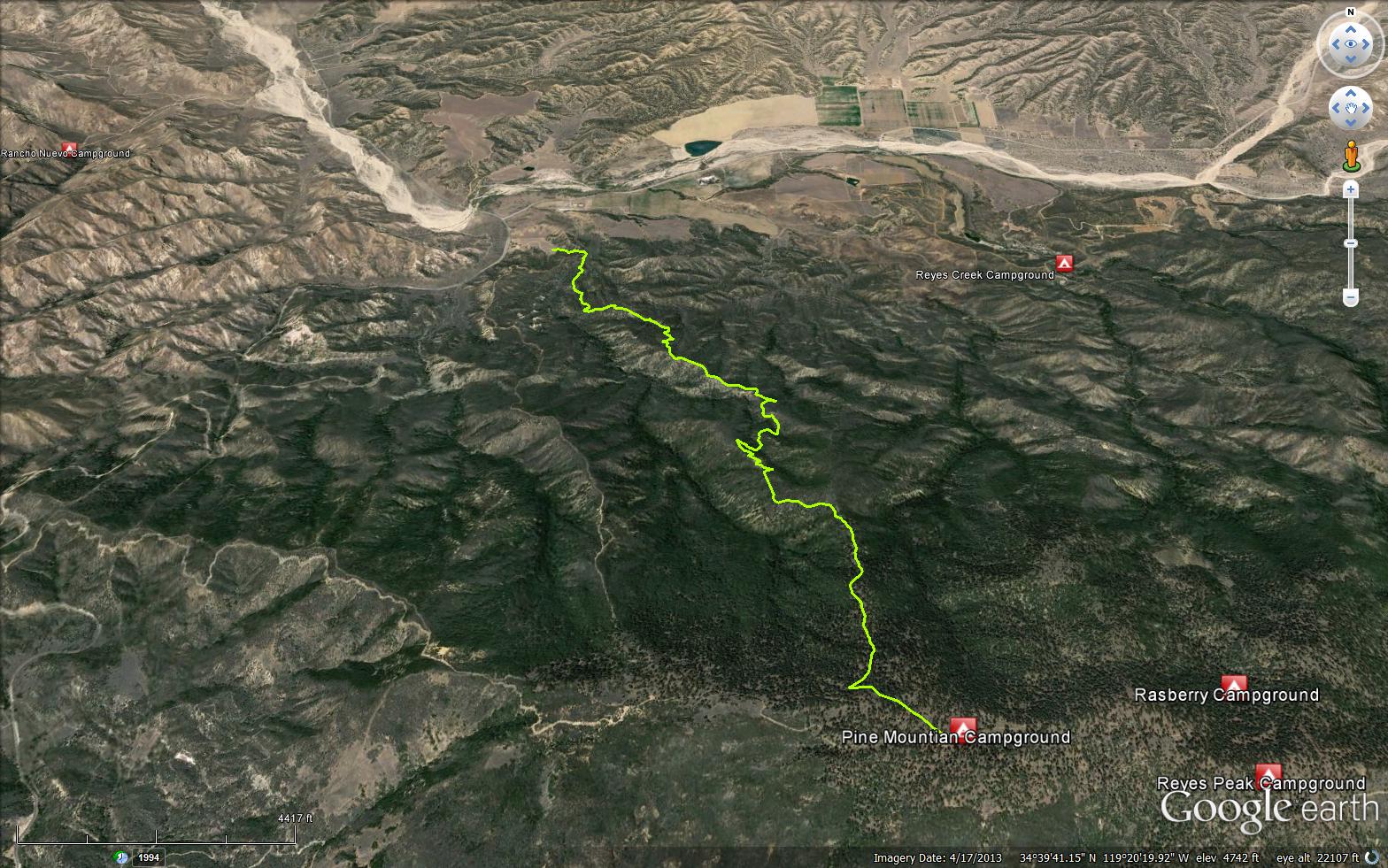
The Bolder Canyon Trail can be accessed either from Pine Mountain Campground or from the HWY 33 at the Ozena Station, the trail climbs steeply from Ozena which is at 3500 feet elevation asending up to the summit and Pine Mountain Campground at 6500 feet. This trail is located just outside of the Sespe Wilderness Area. A small spring named McGuire Spring is located about 1 mile down trail from Pine Mountain Campground . The trail meanders through a wonderfully blissful pine forest, along the trail you will enjoy splendid views of the Lockwood Valley and Mt. Pinos. As you approach Lockwood Valley the flora quickly turns from conifer forest and into desert sage brush and grassland.


.jpeg)
.jpeg)


 Boulder Canyon Trail Survey - 04-22-2026 - by Los Padres Forest Association
| Link: | Boulder Canyon Trail |
| Date: | 04-22-2026 |
| Surveyor Name: | Los Padres Forest Association |
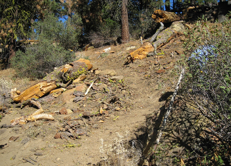
| Trail description: | A combination of LPFA and TDLP volunteers descended Boulder Canyon Trail armed with chainsaws, loppers and a few tread tools. The end result is that all trees were cleared from across the trail along with some much needed brushing and assorted tread work repairs. There are still some brushy sections in the middle of the trail as well as some zones of off-camber tread. Good fun was had by all our beloved Boulder Canyon Trail received some much needed TLC. Next time, come join the fun: VOLUNTEER@LPForest.org |
| Mode of transport: | Array |
| Trail condition: | Good shape and easy to follow |
| Images: | Photo EC_TDLP |
Boulder Canyon Trail Survey - 09-28-2025 - by Los Padres Forest Association| Link: | Boulder Canyon Trail |
| Date: | 09-28-2025 |
| Surveyor Name: | Los Padres Forest Association |
| Trail description: | LPFA volunteers cleared 5 downed trees between the upper trailhead and the chaparral. The trail is in great shape, but is starting to get brushing in the upper chaparral section. It will need a once over soon. |
| Mode of transport: | Hike |
| Trail condition: | Needs some work |
| Condition details: | Great shape from top to chaparral. |
| Images: | Tree before Tree after |
Boulder Canyon Trail Survey - 09-22-2023 - by Los Padres Forest Association| Link: | Boulder Canyon Trail |
| Date: | 09-22-2023 |
| Surveyor Name: | Los Padres Forest Association |
| Trail description: | LPFA spent a day clearing downed trees between the upper trailhead and McGuire Spring, as well as brushing .25 miles of the start of the chaparral section from the top down. Trail is in good shape but has a few more trees down below the spring. The spur trail to the spring is hard to follow with numerous downed trees, but the spring was flowing. Check out photos here! |
| Mode of transport: | Hike |
| Trail condition: | Good shape and easy to follow |
Boulder Canyon Trail Survey - 06-04-2022 - by EC DUZ IT| Link: | Boulder Canyon Trail |
| Date: | 06-04-2022 |
| Surveyor Name: | EC DUZ IT |
| Trail description: | Thanks to Mark S. and Jason B. and the 10 others who made this work day happen! Go get it! |
| Mode of transport: | Bicycle |
| Trail condition: | Good shape and easy to follow |
| Images: | |
Boulder Canyon Trail Survey - 01-23-2021 - by Nancy Aguilar| Link: | Boulder Canyon Trail |
| Date: | 01-23-2021 |
| Surveyor Name: | Nancy Aguilar |
| Trail description: | We started from Ozena fire station. 28 degrees outside but perfect for the climb up. There are about 3 down trees and easy to step over. It is obvious they are out there maintaining the forest. We managed to make it to the Chorro Grande trailhead. We turned around at Chorro because it started snowing. I went out to explore this trail to see what it is like on a mountain bike. I will have to report if you start from Pine Mtn road and head down, it is a downhillers delight. Especially in hero dirt conditions.Yipee |
| Mode of transport: | Hike |
| Trail condition: | Good shape and easy to follow |
| Images: | View headed up At the top. Snow cap trees Trailhead at the start A custom chair : ) |
Boulder Canyon Trail Survey - 08-14-2020 - by Jim Kenney| Link: | Boulder Canyon Trail |
| Date: | 08-14-2020 |
| Surveyor Name: | Jim Kenney |
| Trail description: | We started this hike at the Pine Mtn Camp. We found the trailhead marked and easy to follow. We ignored the branches across a spur trail and went down the ridge a bit before the trail petered out. Headed back up to where we missed our turn and headed downhill. The trail is easy to follow down the hill. If there is any issue with this trail is that it is off camber on the downhill slope with leaves and some scree that requires extra care. There was a small clump of downed tree at 34.64364, -119.32957. We also did not see a trail of any sort to McGuire Spring.  |
| Mode of transport: | Hike |
| Trail condition: | Good shape and easy to follow |
| Images: | |
Boulder Canyon Trail Survey - 06-18-2020 - by ecduzit| Link: | Boulder Canyon Trail |
| Date: | 06-18-2020 |
| Surveyor Name: | ecduzit |
| Trail description: | My sad/frustrated post from November 2019 paid off. We did some "logging" on the upper part of this trail in early June, and I rode down the trail on my mountain bike the next day. The tread needs to be widened in a few areas and a little more brushing is needed in a few spots, but overall the trail is now in pretty good shape! This is one of the of the best mountain bike trails in the Los Padres in my opinion. Go get it! |
| Mode of transport: | Bicycle |
| Trail condition: | Good shape and easy to follow |
| Images: | |
Boulder Canyon Trail Survey - 06-10-2020 - by Matt| Link: | Boulder Canyon Trail |
| Date: | 06-10-2020 |
| Surveyor Name: | Matt |
| Trail description: | Looks like lots of work has recently been done on the trail. It is in really good shape. A bit hard to find as you go over the ridge from Pine Mountain Campground, but once you find it, it is easy to follow. Narrow in many spots, and loose but really fun with amazing views. |
| Mode of transport: | Bicycle |
| Trail condition: | Good shape and easy to follow |
Boulder Canyon Trail Survey - 11-10-2019 - by Erin C| Link: | Boulder Canyon Trail |
| Date: | 11-10-2019 |
| Surveyor Name: | Erin C |
| Trail description: | It is depressing how many conifers died at the top part of this trail during the drought. Deadfall will continue to be an issue on the upper part of this trail for quite some time as these dead  trees continue to fall down. Lower down on the trail the Manzanita and scrub oak have in golfed the trail. Major brushing is needed. I really love this trail and I hope we can bring it back to life soon :-) |
| Mode of transport: | Hike |
| Trail condition: | Needs some work |
| Images: | |
Boulder Canyon Trail Survey - 05-09-2019 - by Diane Soini| Link: | Boulder Canyon Trail |
| Date: | 05-09-2019 |
| Surveyor Name: | Diane Soini |
| Trail description: | The trail is in fairly good condition. It is very steep. A mile or less than 2 miles from the turnoff to the spring the trail just vanished. I spent 40 minutes being stabbed by yuccas trying to find a way through. I'm pretty sure that I didn't just miss something. I was following someone else's foot prints. I'm not sure why the trail was gone. There wasn't a clear cause like a clearly fallen tree. It simply vanished into the scrub. After that the trail continued to be in good condition. The spring was a long drop but it was full and there was a small camp that was pretty battered and worn out. |
| Mode of transport: | Hike |
| Trail condition: | Needs some work |
| Condition details: | A mile or two below the spring the trail disappeared. |
Boulder Canyon Trail Survey - 06-02-2018 - by MSubbotin| Link: | Boulder Canyon Trail |
| Date: | 06-02-2018 |
| Surveyor Name: | MSubbotin |
| Trail description: | 3 MPRD volunteer chainsaw sawyers and 3 swampers cleared all 20+ downed trees reported by Scout Troop 111 on 4.7 miles of trail starting from Pine Mtn CG and finishing at Ozena Fire Station. Â Trail is easy to follow, but tread is very narrow and out-sloped in middle 2 mile section. Â |
| Mode of transport: | Hike |
| Trail condition: | Needs some work |
| Condition details: | Nationals Trails Day MPRD Volunteer trail maintenance project |
| Images: | BEFORE; 41" dia. pine AFTER Typical down tree in top 1.5 mile portion of trail Great views to the north towards Cuyama River & Cuyama Valley |
Boulder Canyon Trail Survey - 05-21-2018 - by Los Padres Forest Association| Link: | Boulder Canyon Trail |
| Date: | 05-21-2018 |
| Surveyor Name: | Los Padres Forest Association |
| Trail description: | Condor Trail Hikers reported: "15 to 23 trees down on Boulder trail depending on if you count the trail
to Maguire spring. Fished a couple dead mice out of the spring box
there and covered the box up as best we could." This trail is scheduled to be worked in June 2018 by MPRD Volunteers. |
| Mode of transport: | Hike |
| Trail condition: | Needs some work |
Boulder Canyon Trail Survey - 03-30-2018 - by Craig R. Carey| Link: | Boulder Canyon Trail |
| Date: | 03-30-2018 |
| Surveyor Name: | Craig R. Carey |
| Trail description: | BSA Troop 111 (Ventura) climbed the Boulder Canyon trail as part of a 17-mile training hike this past Good Friday. Several wash-outs and a few spots in the barren stretch near 34.65802, -119.33463 where you'll need to pick your route a bit. Several downed trees, including some real monsters near the McGuire Spring junction and near the top before you reach Pine Mountain Road. Looks like fire crews have done some dozer work up there recently; there's a section where they bladed over the trail for 40 or 50 feet but it's easy enough to find it again on the other side. |
| Mode of transport: | Hike |
| Trail condition: | Needs some work |
| Images: | |
Boulder Canyon Trail Survey - 04-01-2017 - by Mike Maki| Link: | Boulder Canyon Trail |
| Date: | 04-01-2017 |
| Surveyor Name: | Mike Maki |
| Trail description: | This was downhill. For the most part the trail was easy to follow. A couple of very annoying down trees and probably a dozen total. There is also a small slide near the bottom section that care must be taken to cross. Otherwise trail is in fairly good shape. Spotted a 3/4" PVC coupling on branch indication the trail to McGuire Spring. A few general pics of the trail. |
| Mode of transport: | Hike |
| Trail condition: | Needs some work |
| Condition details: | About a dozen down trees and one cautious slide. Fairly easy to follow. |
| Images: | Large tree down near top of trail. Difficult oak down near bottom of trail. Caution crossing this slide near bottom of trail. White 3/4" PVC indicating trail to McGuire Spring. |
Boulder Canyon Trail Survey - 07-08-2016 - by Los Padres Forest Association| Link: | Boulder Canyon Trail |
| Date: | 07-08-2016 |
| Surveyor Name: | Los Padres Forest Association |
| Trail description: | The Pine Fire continues to burn along the north face of Pine Mtn in the Sespe Wilderness. Â Part of the fire attack was to construct an indirect fire line along the Boulder Canyon Trail. Â Crews have completed this fire line from Ozena Fire Station to Pine Mtn Campground along the Boulder Canyon Trail. Â It will be interesting to visit once the fire is wrapped up. |
| Mode of transport: | Array |
| Trail condition: | Good shape and easy to follow |
Boulder Canyon Trail Survey - 10-18-2015 - by Los Padres Forest Association| Link: | Boulder Canyon Trail |
| Date: | 10-18-2015 |
| Surveyor Name: | Los Padres Forest Association |
| Trail description: | Recent article by ValHikes about a hike up Boulder Canyon. Â Enjoy: http://valhikes.blogspot.com/2015/10/boulder-canyon.html?utm_source=feedburner&utm_medium=email&utm_campaign=Feed%3A+MomentsInDirtAndInk+%28Moments+in+Dirt+and+Ink%29 |
| Mode of transport: | Hike |
| Trail condition: | Needs some work |
Boulder Canyon Trail Survey - 09-13-2015 - by Chester| Link: | Boulder Canyon Trail |
| Date: | 09-13-2015 |
| Surveyor Name: | Chester |
| Trail description: | I started at Ozena station and made it up to the woodland but not as for as the spring. The trail was easy to follow but a little lose and narrow at certain sections. It may have been a little harder to traverse if I had more than a day pack on. Great trail, great views. |
| Mode of transport: | Hike |
| Trail condition: | Good shape and easy to follow |
Boulder Canyon Trail Survey - 10-16-2014 - by Los Padres Forest Association| Link: | Boulder Canyon Trail |
| Date: | 10-16-2014 |
| Surveyor Name: | Los Padres Forest Association |
| Trail description: | The Great Bardlero of Ojai was out doing his thing and removing trees from Boulder Canyon. Â |
| Mode of transport: | Array |
| Trail condition: | Good shape and easy to follow |
| Images: | Bardlero Photo |
Boulder Canyon Trail Survey - 09-01-2014 - by Anonymous Surveyor| Link: | Boulder Canyon Trail |
| Date: | 09-01-2014 |
| Surveyor Name: | Anonymous Surveyor |
| Trail description: | - Tread work needed in canyon areas - Downed tree is at 34 dgr 39 min 00 sec N; 119 dgr 19 min 46 sec W ( see pic) - Four trees down (3 large, 1 medium) on spur trail to McGuire Spring - McGuire Spring has fresh cold water (see pic + camp) - Rattlesnake encountered on trail; bear prints in lower wash area and tree raking ~ 1 mile from Pine Mtn Rd |
| Mode of transport: | Hike |
| Trail condition: | Needs some work |
| Condition details: | 1 large tree down about 15 min from Pine Mtn Road |
| Number of trees down: | 1 |
| People Seen: | 0 |
| Images: | |
Boulder Canyon Trail Survey - 03-29-2014 - by Anonymous Surveyor| Link: | Boulder Canyon Trail |
| Date: | 03-29-2014 |
| Surveyor Name: | Anonymous Surveyor |
| Trail description: | - Trail is in good shape - had trail to myself, first tracks since last rain - Dress for ticks - plucked 10 off my clothes - McGuire Spring is full, cold, and deep - Saw grey squirrel, blue jay, biggest lizard ever, - Signs of deer, cows, mice, mtn lion |
| Mode of transport: | Hike |
| Trail condition: | Needs some work |
| Condition details: | 1 large tree across trail about 10 minutes into the pines |
| Number of trees down: | 1 |
 Survey / Report Form - Please click this box to open the form.