Welcome To Hike Los Padres!
User Log In or Sign Up
Use Marker Cluster
Markers: Use Marker Groups
Time used: ms
Routes
    Trails
    OHV Trails
    Forest Roads
    Streams
Wildfire Layers
    Wolf 2002
    Piru 2003
    Day 2006
    Zaca 2007
    Gap 2008
    La Brea 2009
Forest Layers
    Forest Boundary
    Wilderness Areas
    Ranger Districts
    Counties
    Topographic Outlines
    Trailheads
    OHV Trailheads
Helpful Hints
    ↣ Right click the map for location data. ↣ Click a stream for Water Stats.

Black Mountain Trail - Los Padres National Forest
Trail Distance 3.09 Miles

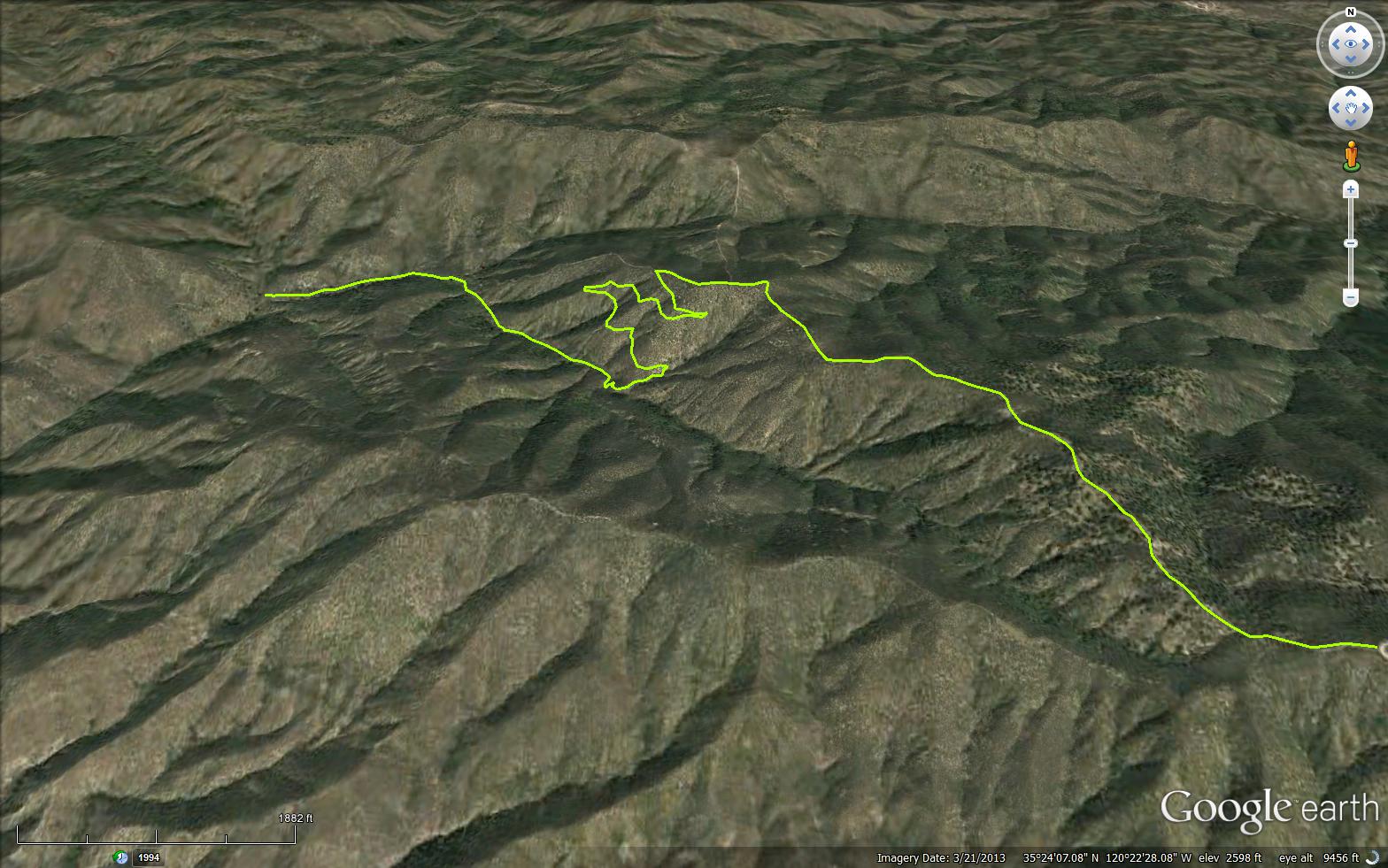
The Black Mountain Trail is a scenic 3.09 mile trail in San Luis Obispo County . The trail connects the Wilson Canyon Trail 15E01 and the Black Mountain Road (29S10).
Please let us know if you have explored this trail recently.


Trail Details

  • Trail #: 15E03
  • Wilderness Area: Non Wilderness Area
  • County: San Luis Obispo County
  • Ranger District: Santa Lucia Ranger District
  • Trail-head Latitude: 35.3948
  • Trail-head Longitude: -120.36034
  • Trail Condition: Kind of Good - Little to no bushwacking and easily followable
  • Topo Maps:
  • Activities & Features:
    • Day Hiking
    • Horseback Riding
    • Mountain Biking
    • Wildlife Viewing


Trail Stats

  • Total Elevation Gain: + 338 feet.
  • Total Elevation Loss: - 1555 feet.
  • Overall Average Slope Gain: + 7 %.
  • Overall Average Slope Loss: - 12 %.
  • Kilometers: (km)
  • Meters: (m)
  • Miles: (mi)
  • Feet: (ft)
  • Average Slope: (%)
Upload Images Aerial Overview Image Login to Download GPS File
Survey This Trail

Survey Photos:


  • Anonymous Surveyor - 06-06-2020

  • Anonymous Surveyor - 06-06-2020

  • Anonymous Surveyor - 06-06-2020

Submitted Trail Reports

Black Mountain Trail Survey - 06-06-2020 - by Anonymous Surveyor
Link: Black Mountain Trail
Date: 06-06-2020
Surveyor Name:Anonymous Surveyor
Trail description:I hiked the fist ~1.25 miles of this trail on 6-6-20.  Some brush encroaching on trail but still easy to follow.  Trail surface is crumbly sand that makes some downhill sections challenging.  About 1 mile in the trail makes a sharp left turn (at a directional arrow sign) and then the trail deteriorates very badly.  It's eroded almost to nothing along a steep ledge.  This appears to be the beginning of the switchback section on the map above.  Might be passable for an intrepid hiker with poles but I turned back at this point.
Mode of transport:Hike
Trail condition:Needs some work
Condition details:First mile good with some loose slopes; very eroded after one mile
Images:

Near trailhead

Looking northeast


Past arrow sign. Here the trail is too degraded to hike easily.


Leave A Trail Report

Survey / Report Form - Please click this box to open the form.


Last Updated: Tuesday, March 1, 2016


Join Mailing List
×
Get updates on conditions, surveys and more...


Current Weather »


L.P.N.F. Contacts »

  • Forest Headquarters
    Phone: (805) 968-6640
  • Mt. Pinos District
    Phone: (661) 245-3731
  • Ojai Ranger District
    Phone: (805) 646-4348
  • Santa Barbara District
    Phone: (805) 967-3481
  • Santa Lucia District
    Phone: (805) 925-9538
  • Monterey District
    Phone: (831) 385-5434