Welcome To Hike Los Padres!
User Log In or Sign Up
Use Marker Cluster
Markers: Use Marker Groups
Time used: ms
Routes
    Trails
    OHV Trails
    Forest Roads
    Streams
Wildfire Layers
    Wolf 2002
    Piru 2003
    Day 2006
    Zaca 2007
    Gap 2008
    La Brea 2009
Forest Layers
    Forest Boundary
    Wilderness Areas
    Ranger Districts
    Counties
    Topographic Outlines
    Trailheads
    OHV Trailheads
Helpful Hints
    ↣ Right click the map for location data. ↣ Click a stream for Water Stats.

Big Sur Trail - Los Padres National Forest
Trail Distance 8.80 Miles

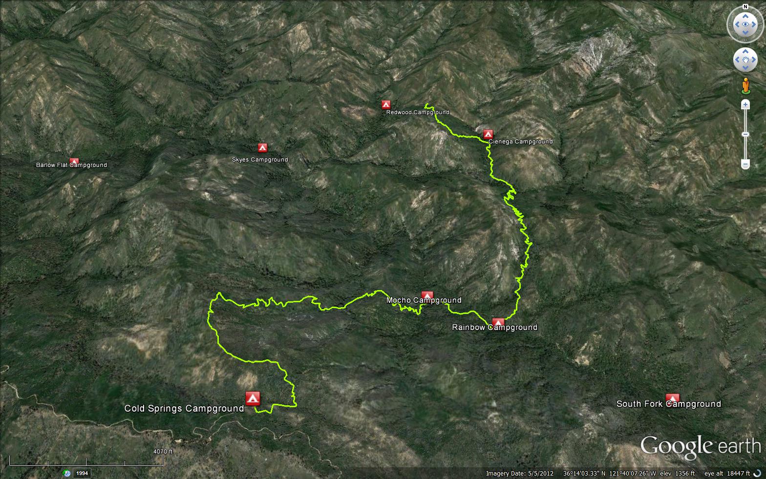
The Big Sur Trail is a scenic 8.80 mile trail in the Ventana Wilderness in Monterey County . The trail starts at Cold Springs Campground (3200 feet) and connects to the Pine Ridge Trail (3E06). Please let us know if you have explored this trail recently. 

Trail Details

  • Trail #: 3E07
  • Wilderness Area: Ventana
  • County: Monterey County
  • Ranger District: Monterey Ranger District
  • Trail-head Latitude: 36.21252399
  • Trail-head Longitude: -121.6801369
  • Water Sources: Water is available from multiple creeks along the trail, see trail camp links below for water reports
  • Trail Condition: Kind of Good - Little to no bushwacking and easily followable
  • Topo Maps:
  • Activities & Features:
    • Backpacking
    • Car Camping
    • Camping
    • Campfire Rings
    • Day Hiking
    • Panoramic Views
    • Wildlife Viewing
    • Wilderness Camping


Trail Stats

  • Total Elevation Gain: + 4124 feet.
  • Total Elevation Loss: - 5066 feet.
  • Overall Average Slope Gain: + 16 %.
  • Overall Average Slope Loss: - 17 %.
  • Kilometers: (km)
  • Meters: (m)
  • Miles: (mi)
  • Feet: (ft)
  • Average Slope: (%)

Trail Camps

  1. Cienega Camp (1700 feet)
  2. Rainbow Camp (1550 feet)
  3. Mocho Camp (1600 feet)
  4. Cold Springs Campground (3200 feet)
Upload Images Aerial Overview Image Login to Download GPS File
Survey This Trail

Submitted Trail Reports

Big Sur Trail Survey - 06-25-2016 - by Anonymous Surveyor
Link: Big Sur Trail
Date: 06-25-2016
Surveyor Name:Anonymous Surveyor
Mode of transport:Hike
Trail condition:Hard to follow
Big Sur Trail Survey - 01-07-2015 - by matthew mcurk
Link: Big Sur Trail
Date: 01-07-2015
Surveyor Name:matthew mcurk
Trail description:This was an epic bushwhack other than  first half mile ended up bushwhacking to north fork junction then up the creek to cienaga could not find evidence that the trail continued on my hiking partner and I bush whacked on a bearing through dense yucatan style brush to get back up the canyon although we both enjoyed it not for anyone but the most seasoned los padres hiker.
Mode of transport:Hike
Trail condition:Non existent
Condition details:epic bushwack


Leave A Trail Report

Survey / Report Form - Please click this box to open the form.


Last Updated: Tuesday, March 1, 2016


Join Mailing List
×
Get updates on conditions, surveys and more...


Current Weather »


L.P.N.F. Contacts »

  • Forest Headquarters
    Phone: (805) 968-6640
  • Mt. Pinos District
    Phone: (661) 245-3731
  • Ojai Ranger District
    Phone: (805) 646-4348
  • Santa Barbara District
    Phone: (805) 967-3481
  • Santa Lucia District
    Phone: (805) 925-9538
  • Monterey District
    Phone: (831) 385-5434