Welcome To Hike Los Padres!
User Log In or Sign Up
Use Marker Cluster
Markers: Use Marker Groups
Time used: ms
Routes
    Trails
    OHV Trails
    Forest Roads
    Streams
Wildfire Layers
    Wolf 2002
    Piru 2003
    Day 2006
    Zaca 2007
    Gap 2008
    La Brea 2009
Forest Layers
    Forest Boundary
    Wilderness Areas
    Ranger Districts
    Counties
    Topographic Outlines
    Trailheads
    OHV Trailheads
Helpful Hints
    ↣ Right click the map for location data. ↣ Click a stream for Water Stats.

Bear Canyon Loop OHV Trail - Los Padres National Forest
Trail Distance 6.09 Miles

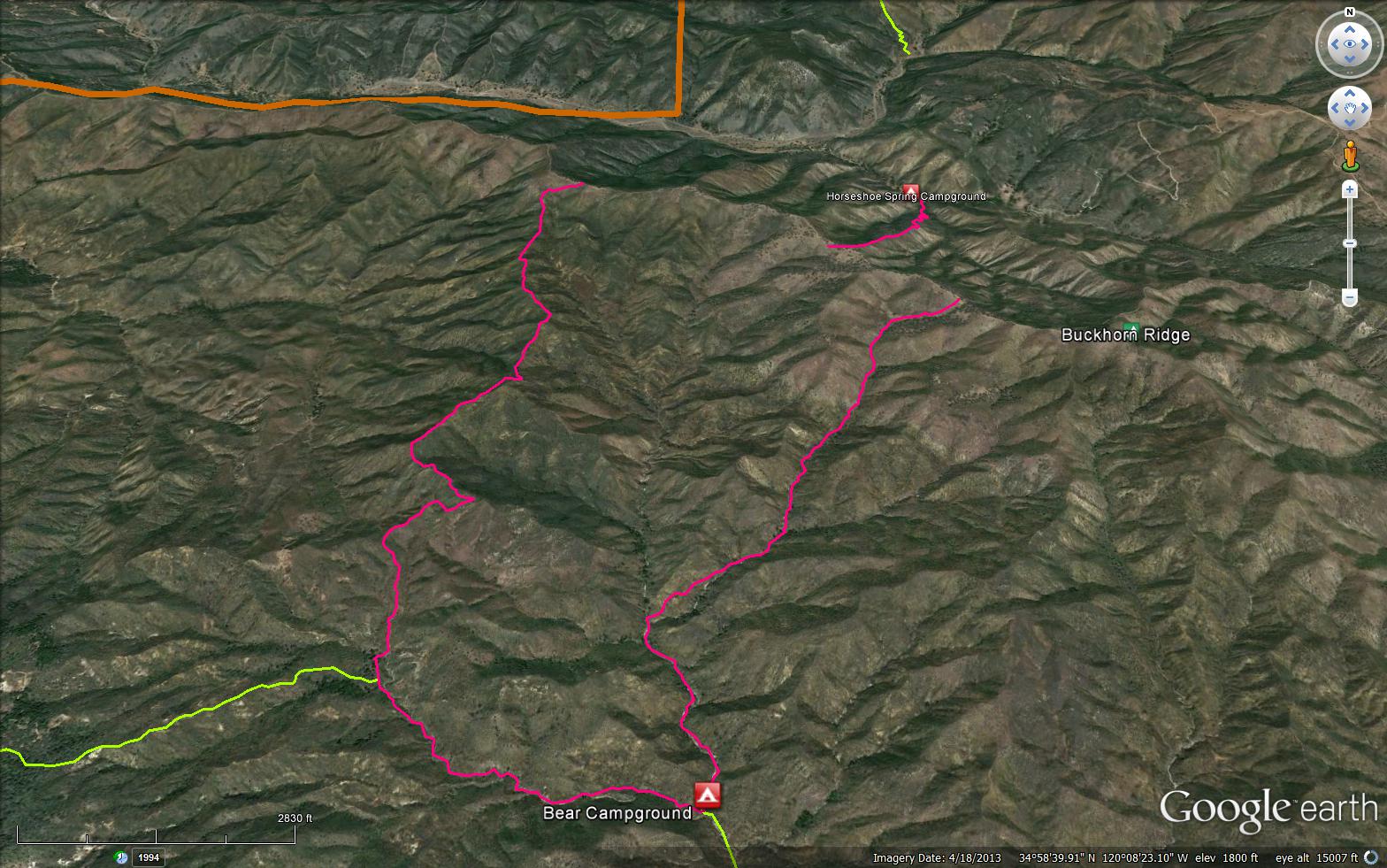
This steep narrow trail leaves the Buckhorn Ridge route and drops down into Bear Canyon Camp where it connects to the Bear Canyon trail, connecting back to Buckhorn Ridge route. This trail is for the most advanced motorcycle riders.

Trail Details

  • Trail #: 31W13
  • Wilderness Area: Non Wilderness Area
  • County: Santa Barbara County
  • Ranger District: Santa Lucia Ranger District
  • Trail-head Latitude: 34.99436
  • Trail-head Longitude: -120.14635
  • Trail Condition: Moderate
  • Topo Maps:
  • Activities & Features:
    • Mountain Biking
    • OHV Area


Trail Stats

  • Total Elevation Gain: + 1984 feet.
  • Total Elevation Loss: - 1883 feet.
  • Overall Average Slope Gain: + 10 %.
  • Overall Average Slope Loss: - 12 %.
  • Kilometers: (km)
  • Meters: (m)
  • Miles: (mi)
  • Feet: (ft)
  • Average Slope: (%)
Upload Images Aerial Overview Image Login to Download GPS File
Survey This Trail

Survey Photos:


  • Los Padres Forest Association - 05-03-2020

  • Los Padres Forest Association - 05-03-2020

  • Los Padres Forest Association - 05-03-2020

Submitted Trail Reports

Bear Canyon Loop OHV Trail Survey - 05-03-2020 - by Los Padres Forest Association
Link: Bear Canyon Loop OHV Trail
Date: 05-03-2020
Surveyor Name:Los Padres Forest Association
Trail description:The LPFA Trail Crew will be working this trail later this month.  We scouted the eastern branch of the trail to see what we were up against.  There is no sign for the trail but it starts on the western edge of a small pond and from there drops down through heavy grass for about 1/4 of a mile before entering the chaparral.  Once in the chaparral the trail is easy enough to follow but is overgrown.  It would not be an enjoyable motorcycle ride at the moment but the tread appears in good enough shape that once we clear away the brush this could be a good ride once again.
Mode of transport:Hike
Trail condition:Hard to follow
Images:

Trailhead on west side of pond

First 1/4 mile of waist high grass


Into the chaparral, tread is under there, somewhere......


Leave A Trail Report

Survey / Report Form - Please click this box to open the form.


Last Updated: Wednesday, March 30, 2016


Join Mailing List
×
Get updates on conditions, surveys and more...


Current Weather »


L.P.N.F. Contacts »

  • Forest Headquarters
    Phone: (805) 968-6640
  • Mt. Pinos District
    Phone: (661) 245-3731
  • Ojai Ranger District
    Phone: (805) 646-4348
  • Santa Barbara District
    Phone: (805) 967-3481
  • Santa Lucia District
    Phone: (805) 925-9538
  • Monterey District
    Phone: (831) 385-5434