 Use Marker Groups
 Wolf 2002
Piru 2003
Day 2006
Zaca 2007
Gap 2008
La Brea 2009

| Date | Surveyor | Water Report |
| 05-16-2021 | Anonymous Surveyor | Dry |
| 08-08-2020 | Oh Three | Dry |
| 06-13-2020 | Tim Cameron | Dry |


 Alamo Mountain Survey - 05-16-2021 - by Anonymous Surveyor
| Link: | Alamo Mountain |
| Date: | 05-16-2021 |
| Surveyor Name: | Anonymous Surveyor |
| Camp Description: | Went up to the summit of Alamo Mountain on 5/16/21. Started and finished at Dutchman Campground. It was a 4 mile loop with about 500 feet of elevation gain. Would rate the difficulty at 4/10 due to conditions (fallen trees and some intense wind near the summit.) No water other than a horse drinking trough on the north side of mountain along the dirt road. Camped at Dutchman Campground, very pleasant. The hike started and ended on the dirt road. Saw plenty of chipmunks and a deer. Don’t have much else to say other than nice views from the summit. |
| Water Source: | Dry |
| Water Source Details: | No water other than a horse drinking trough on the main road |
| Weather Conditions: | 50 to 55 degrees during the day and 35 to 40 at night. |
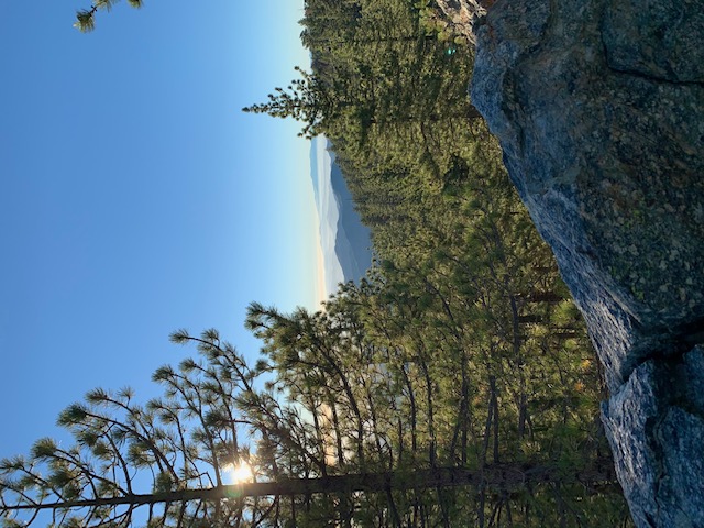
| Images: | Lupine on summit ridge Near the summit at 7,100 feet. |
Alamo Mountain Survey - 08-08-2020 - by Oh Three| Link: | Alamo Mountain |
| Date: | 08-08-2020 |
| Surveyor Name: | Oh Three |
| Camp Description: | Bivouac'ing on the summit is a easy & scenic backpack overnight, if you drive to the high point on the road into the old Twin Pines Campground, and start hiking from there. As you go up the ridge, the correct "road" is the 2nd one leading off to the right (west). Both roads are faint memories, covered with pine cones, but you want to take the second one, slightly higher on the mountainside. It switchbacks once and takes you to the saddle. Turn right (west again), and go to the 2nd summit, which is the real summit. Like Tim C said, you won't see anyone on this hike, other than deer. Unfortunately, as documented in the photo, the off road yahoo's have also gone up Alamo from this point, trashing the thin layer of vegetation. There's never a ranger around when you need one.. |
| Water Source: | Dry |
| Water Source Details: | Big Spring is nearby |
| Weather Conditions: | |
| Images: | Alamo Mt Summit Alamo Mt Sunset Alamo Mt Off Road Vehicles |
Alamo Mountain Survey - 06-13-2020 - by Tim Cameron| Link: | Alamo Mountain |
| Date: | 06-13-2020 |
| Surveyor Name: | Tim Cameron |
| Camp Description: | On June 13th, I left Highway 5 and drove down Gold Hill Road (very rough with a lot of pot-holes), parking at the Piru Trail junction. I hiked Piru Trail and then did the brutal 3000-ft climb to Dutchman Campsite via Miller Jeep Trail. I then walked around Alamo Mountain to Big Spring, filling up several liters of water before scrambling up to the summit (7367 feet). This approach hike was approximately 11 miles total. The approach trail along Piru Creek was very pleasant: it's frequented by motorcyclists but only one group passed me. Piru Creek is still flowing healthily as of June 2020. Alamo is an off-road mecca: expect to encounter plenty of 4WD vehicles if you're visiting at the weekend. All my encounters were pleasant: at one point, a guy in a jeep shouted "now there's a real off-roader" when he saw me! The jeeps were headed for Miller Jeep Trail, which leads up Alamo Mountain to Dutchman Campground. This trail is extremely challenging, even for high-clearance vehicles: I ended up overtaking a column of 15 jeeps who were all stuck halfway up the hill. I have no idea if they made it. After slogging up Miller Jeep Trail, which is very steep and shade-free, I finally emerged at Dutchman Campground. This is a wide-open, picturesque site with privies and fire pits, and plenty of shade thanks to the conifers that grow abundantly above 6000 feet. There are usually 4WD vehicles here, most of which arrive via Gold Hill Road, which is a far easier access road than Miller, although you'll still need a high-clearance vehicle to get up. For water, I took the dirt road from Dutchman to Big Spring, a horse trough fed by a small hose. The trough is full of buggy, stagnant water, but there are multiple seeps in the area which can be expanded with a little digging, allowing you to scoop up some lovely fresh spring water. These will likely dry up in July, although you can still use the horse trough if there's no other choice. After filling up, I scrambled straight up to the top of Alamo Mountain, discovering halfway up that there's an ancient, long-disused forest road that goes from Big Spring all the way to the top. Look for Twin Pines Campground (it doesn't show on every map) - the old forest road starts there. If you can't find Twin Pines on your map, look for a small side-road near Big Spring that terminates nearby in a loop - that's the campsite. The top of Alamo Mountain is gorgeous. Abundant grassy camp spots, plenty of trees for shade, and spectacular views of the desert to the North and East, and of the rest of Los Padres to the South and West. But beware of the wind! There was the lightest of breezes while I was setting up, but as soon as the sun went down, the gale started blasting. Definitely use all your guy-lines if you're planning to camp. The next day, I made my way back down the disused forest road and then walked Gold Hill Road for 7 miles back to the car. The views were lovely, but road walking is always a let-down. My feet were on fire by the time I got back to the car. If I were to camp here again, I'd probably drive all the way up to Dutchman and then hike the short way to the top: although Piru Trail is pleasant to hike, both Miller Jeep Trail and Gold Hill Road are shade-less slogs to get through. However, the magical summit ridge is well worth a visit if you have the car for the job. |
| Water Source: | Dry |
| Water Source Details: | No water at the top of Alamo Mountain, but the nearby Big Spring is still flowing |
| Weather Conditions: | Hot and sunny (80's) during the day. Temperature fell and wind rose dramatically at night |
| Images: | Taking the Piru trail along Piru Creek. This trail joins up with the Miller Jeep Trail at Sunset Campground, and goes up to Dutchman Campground. A big climb! Dutchman is an open, pleasant campground with privies. High-clearance 4WD vehicles can make it up, but take Gold Hill Road: the Miller Jeep Trail is very challenging. There is a long-disused forest road that goes from near Big Spring all the way to the top of the mountain, but it can be difficult to spot. Spectacular views from the summit ridge of Alamo Mountain. Tent spots are plentiful at the summit, and you're not likely to bump into other people due to the absence of official trails. |

 Survey / Report Form - Please click this box to open the form.