 Use Marker Groups
 Wolf 2002
Piru 2003
Day 2006
Zaca 2007
Gap 2008
La Brea 2009

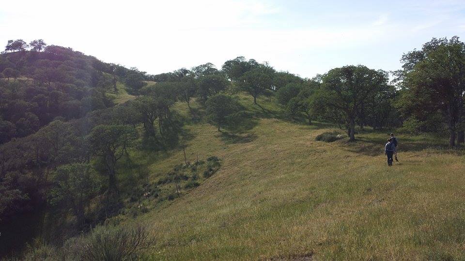
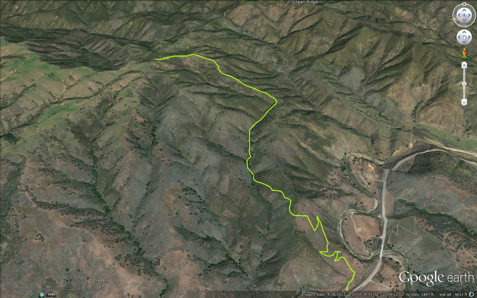
This trail starts off on Highway 166 outside of Santa Maria at a elevation of 1200 feet. The Adobe trail is a gentle trail and is in good shape for hiking and stock. From the trail head you climb up a grassy knoll via switch backs, with a view of the Highway 166 and the trail head you just started from. The Adobe trail quickly drops into a chaparral zone and then slowly into the calm canyon. This portion of the trail weaves in and out of the oaks trees that line this area. Follow this portion of trail along the seasonal creek for about a mile, then the trail starts to climb along a grassy ridge until you reach the which is Twin Rocks Road (Forest Route 17E12). From here you can walk the road down a short distance and then take a side cattle trail back to HWY 166 or return the way you have hiked. This is a non Wilderness Area so feel free to Mountain Bike it up and get crazy, if so think about making this a loop trip via the side trail off Twin Rocks Road (Forest Route 17E12) back to HWY166 then just take the HWY 166 back to the trail head. As always be respectful to others to on the trail, do not forget a bell if on a bike.
This trail should be hiked in cooler weather, take caution since this trail does not provide very antiquate shade and this area tends to get very warm during summer months.
Grassland, Oaks, Chaparral
Closest Camp is Baja Campground


 Adobe Trail Survey - 12-21-2025 - by Anonymous Surveyor
| Link: | Adobe Trail |
| Date: | 12-21-2025 |
| Surveyor Name: | Anonymous Surveyor |
| Trail description: | Unable to hike trail due to gate locked closed to get to parking lot. Entire parking lot is fenced off, so the trail appears to be closed. |
| Mode of transport: | Hike |
| Trail condition: | Non existent |
| Condition details: | The parking lot gate was closed. |
Adobe Trail Survey - 04-22-2023 - by Anonymous Surveyor| Link: | Adobe Trail |
| Date: | 04-22-2023 |
| Surveyor Name: | Anonymous Surveyor |
| Trail description: | The ridge trail is beautiful and clear to Twin Rocks Road. The creek trail loop part is wiped out. You can still follow the creek but most of the trail is eroded away. Ticks, poison oak, bushwhacking, and rock hopping are all part of using the creek trail. |
| Mode of transport: | Hike |
| Trail condition: | Needs some work |
| Condition details: | It needs a lot of work. Easy to follow because it is a creek. |
Adobe Trail Survey - 12-25-2018 - by Katy| Link: | Adobe Trail |
| Date: | 12-25-2018 |
| Surveyor Name: | Katy |
| Trail description: | Beautiful hike. Day after light rain, cool and cloudy, perfect hiking conditions. Trail conditions were good.There are two options for getting to to the top: left takes you into the canyon, right over the knoll to the right of the canyon, both rejoin c.1/2 mile from the top. There is a barbed wire gate near the top. |
| Mode of transport: | Hike |
| Trail condition: | Good shape and easy to follow |
| Images: | View from the top |
Adobe Trail Survey - 06-12-2017 - by Los Padres Forest Association| Link: | Adobe Trail |
| Date: | 06-12-2017 |
| Surveyor Name: | Los Padres Forest Association |
| Trail description: | The lower canyon route is pretty thick with brush and thistle. |
| Mode of transport: | Hike |
| Trail condition: | Needs some work |
Adobe Trail Survey - 12-17-2016 - by Anonymous Surveyor| Link: | Adobe Trail |
| Date: | 12-17-2016 |
| Surveyor Name: | Anonymous Surveyor |
| Trail description: | Main trail is very easy to follow. Â There isn't much shade and there is no water so plan accordingly. Â Great views from the top, no poison oak, overall quite nice. |
| Mode of transport: | Hike |
| Trail condition: | Good shape and easy to follow |
| Images: | |
Adobe Trail Survey - 03-18-2015 - by Meghan Sheen| Link: | Adobe Trail |
| Date: | 03-18-2015 |
| Surveyor Name: | Meghan Sheen |
| Trail description: | Trail is in good condition, easy to get off main trail due to extensive mountain bike trails and no trail markers. No water. No poison oak or ticks that we saw. Fun trail overall. |
| Mode of transport: | Hike |
| Trail condition: | Needs some work |
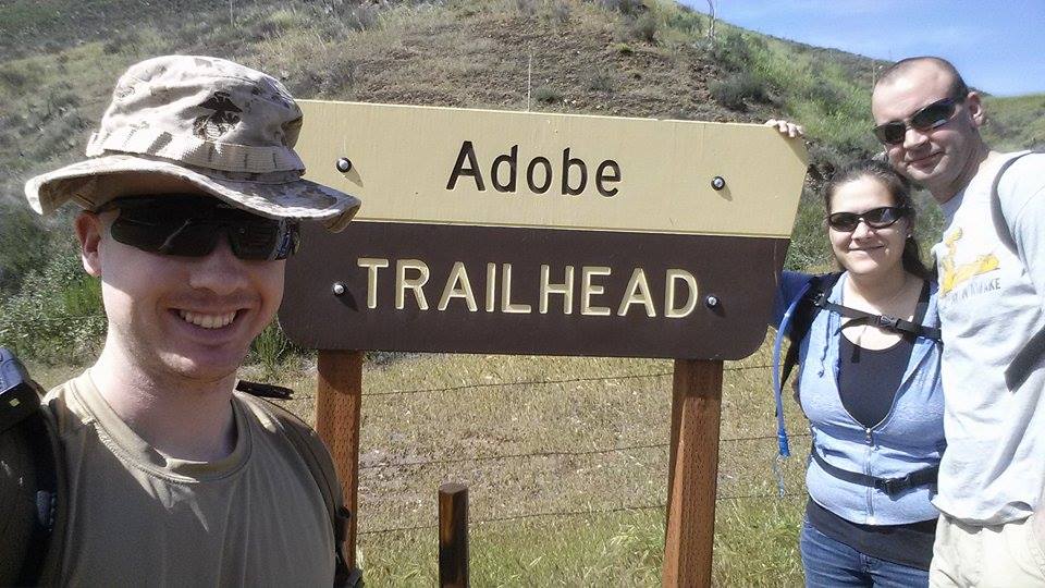
| Images: | Trailhead |

 Survey / Report Form - Please click this box to open the form.