 Use Marker Groups
 Wolf 2002
Piru 2003
Day 2006
Zaca 2007
Gap 2008
La Brea 2009

| Date | Surveyor | Water Report |
| 12-31-2023 | Joel B | Flowing |
| 12-16-2023 | Peter | Flowing |
| 04-15-2023 | Anonymous Surveyor | Flowing |
| 12-31-2021 | Anonymous Surveyor | Flowing |
| 05-30-2020 | Jeremy K | Flowing |
| 03-07-2018 | Mike Maki | Flowing |
| 04-30-2017 | Matt Inman-Ojai Valley School | Flowing |
| 06-11-2016 | Green Machine (aka Perry Way) | Flowing |
| 02-21-2015 | Curt Cragg | Flowing |
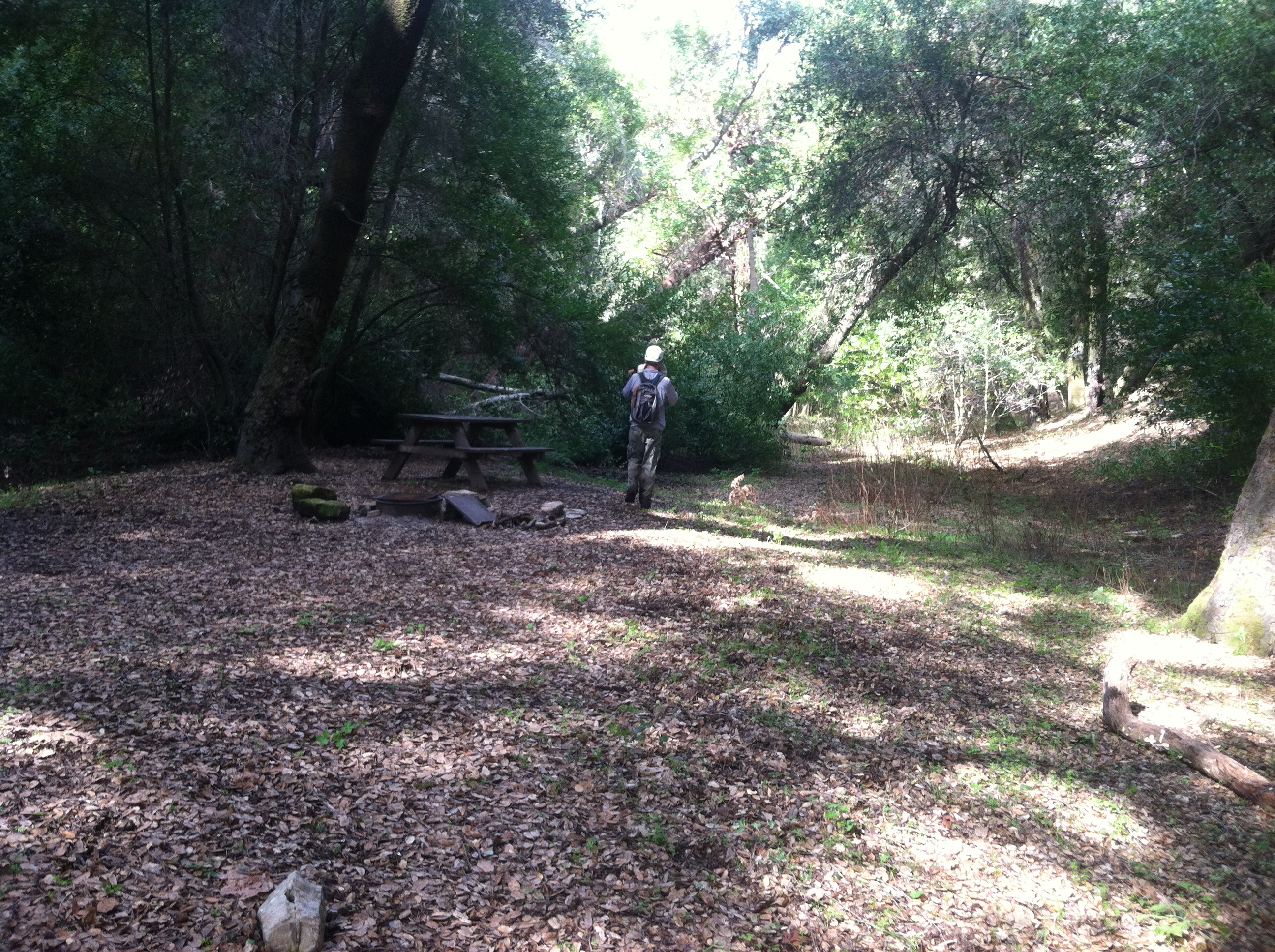
Upper Lopez Camp is within the Santa Lucia Wilderness along the Lopez Canyon Trail. There is reliable water within Lopez Canyon and quite a bit of animal activity. The camp has a table and is set amongst some beautiful large oak trees.


 Upper Lopez Camp Survey - 12-31-2023 - by Joel B
| Link: | Upper Lopez Camp |
| Date: | 12-31-2023 |
| Surveyor Name: | Joel B |
| Camp Description: | Camped here 12/30/23. Trail was not too bad most of the way. The last mile to upper lopez camp had a lot of deadfall and some of the creek crossings were not super clear. My buddy and I did as much trail clearing as we could with a small saw and loppers. Hopefully it makes the next groups hike a little easier. I plan to go back out and spend more time on trail maintenance when its not pouring rain. Overall though, the trail could be followed pretty easily. There was some scat on the trail, it might have been bear but I am not certain. |
| Water Source: | Flowing |
| Water Source Details: | Clear, strong flow. Generally 4-6 feet across |
| Weather Conditions: | Rainy and chilly |
Upper Lopez Camp Survey - 12-16-2023 - by Peter| Link: | Upper Lopez Camp |
| Date: | 12-16-2023 |
| Surveyor Name: | Peter |
| Camp Description: | I scouted the trail on November 11, 2023 with the intention to backpack overnight at Upper Lopez Camp in the future. I saw reports/reviews here and on All Trails of the bad condition of the trail and the need for maintenance, so I brought some tools (hand shears, pruning saw, loppers) with me to do some clearing on my way through. I cut back a lot of overgrowth in a lot of sections, cut/removed fallen trees/branches from the trail entirely and made some fallen trees that were too big to remove with hand tools passable by making holes/paths through/under them. I also pulled logs over to the creek in several places to make crossings easier. On this trip in November, I made it about 0.5 mile from Upper Lopez Camp, but turned back as it was getting late in the day and didn't want to hike back in the dark. There are washouts throughout and the trail is generally unstable as you get further into it, so good hiking shoes/boots and trekking poles are good to have if you don't want to be falling and slipping all the time. I returned on December 16, 2023 to make it to Upper Lopez Camp this time. I brought tools with me again to do more trail maintenance beyond where I last made it to. I made it to Upper Lopez Camp, but it was ABSOLUTELY BRUTAL and not worth the amount of bushwhacking, effort, and time it takes to make it there, so I definitely recommend not to even try. In fact, there is a nice wide open flat space with a make shift fire ring that makes a perfect camp spot before getting to Upper Lopez Camp, but even getting to this spot it takes some bushwhacking, scrambling and time to make your way through sections. I used a GPS app (Gaia GPS) with an actual map of the trail on both trips, but on this trip it was evident that a GPS app is absolutely necessary to not get lost as all of a sudden you're on a semi visible trail and next thing you know you're in a jungle with no trail in sight and repeat. Without a GPS map, you will get lost. Also, beyond the wide open spot with the make shift fire ring, the "trail" is absolutely horrendous. There are LOTS of HUGE fallen trees all over the place that leave you no choice, but to climb up and around them on to steep unstable hillside, then back down, then back up, repeat. This is where having good shoes/boots and trekking poles to steady yourself are absolutely necessary as it's pretty dangerous and very easy to get hurt. I think it goes without saying, but pants, long sleeves and even a mosquito net for your face/head are highly recommended. There are some trees with with initials and the number 4 carved into them on the path to ULC if that's helpful. Upper Lopez Camp itself was in decent shape. The metal fire ring is still there and there is a shovel and rake too. The picnic table is in good condition. The stream runs right next to the camp which is convenient for filtering water. But like I mentioned before, it's not worth trying to make it to this camp. Stay at the nice wide open flat spot with the make shift fire ring. There's plenty of space for several tents and it's open to the sky so you can get nice views of the stars at night. Upper Lopez Camp is pretty much under all tree cover. Fun fact, as you get a few miles into the trail keep an eye out for pink trail tape marking where to go. It is definitely helpful so thank you to the person who put them up. It must have been years ago as the tape is clearly aged and deteriorating with the weather. I detached and re-attached the tape in areas where the trail has shifted to make it easier spot, and also put up bits that fell to the ground in areas that weren't marked at all, but could definitely use it to help guide people through. In some sections where it's not clear where to go, I laid out logs and tree branches in a line on the ground to signal what direction to go in, so hopefully that catches people's eyes to help them out. Next time I go, I will bring some trail tape with me to mark the trail to the nice wide open camp spot I talked about to make it easier for people to find their way there. There's swarms of ladybugs covering trees all over throughout the trail, super cool! I came across 2 black bears (and lots of their scat throughout the trail), one on a hillside a couple of miles into the trail and another on the Mt. Lowe dirt road when I was hiking out in the evening. They both ran off when I yelled at them, but I had bear spray on me just in case. |
| Water Source: | Flowing |
| Water Source Details: | Water is flowing very well in most sections. |
| Weather Conditions: | Clear skies, but almost entirely shaded on trail and therefore cool weather. Gets windy on Mt. Lowe dirt road. |
| Images: | About 5/6 switchbacks in, the trail leads you through a dry creek bed for awhile. Pink trail tape hanging from tree across from creek where I placed some logs for crossing. Lots of ladybugs! Fallen red tree/dead logs I pulled across another creek for crossings. Trail continues on just ahead. Nice open spot w/ make shift fire ring. Great alternative camp site to ULC which is further ahead. |
Upper Lopez Camp Survey - 04-15-2023 - by Anonymous Surveyor| Link: | Upper Lopez Camp |
| Date: | 04-15-2023 |
| Surveyor Name: | Anonymous Surveyor |
| Camp Description: | Fully overgrown with poison oak everywhere. Had to climb over at least 100 downed trees and often questioned whether we were on the actual trail. the creek is flowing hard and everything is green, but poison oak wherever you look and it completely unavoidable. Would not recommend coming from the North, not sure of how the rest of the trail is from the south. |
| Water Source: | Flowing |
| Water Source Details: | Deep pools in some spots, very clean water, flowing very well. |
| Weather Conditions: |
Upper Lopez Camp Survey - 12-31-2021 - by Anonymous Surveyor| Link: | Upper Lopez Camp |
| Date: | 12-31-2021 |
| Surveyor Name: | Anonymous Surveyor |
| Camp Description: | |
| Water Source: | Flowing |
| Water Source Details: | Water flow was strong and the water was clean. Approx 6-8 inches deep. |
| Weather Conditions: | Foggy on the ridge but clear down at the camp. Low temp was around 35 |
Upper Lopez Camp Survey - 05-30-2020 - by Jeremy K| Link: | Upper Lopez Camp |
| Date: | 05-30-2020 |
| Surveyor Name: | Jeremy K |
| Camp Description: |  I came from the Cuesta Grade trail head. I parked at the locked gate and backpacked up the grade. The camp is accessible. The trail is visible the whole way. There are about 5 trees down across the trail, however alternative paths have been made. Lots of poison oak and ticks. It's a beautiful hike and worth the effort.   |
| Water Source: | Flowing |
| Water Source Details: | River |
| Weather Conditions: |
Upper Lopez Camp Survey - 03-07-2018 - by Mike Maki| Link: | Upper Lopez Camp |
| Date: | 03-07-2018 |
| Surveyor Name: | Mike Maki |
| Camp Description: | Just passed by this camp as part of section hike of Condor Trail. Plenty of water in the creek. Crossing are wet especially if coming from the east. Lots of poison oak encroaching on trail but trail easy to follow. Some large down oaks on the climb in and out from Mt Lowe. |
| Water Source: | Flowing |
| Water Source Details: | Camp looks good |
| Weather Conditions: | Nice. |
| Images: | Lopez Camp |
Upper Lopez Camp Survey - 04-30-2017 - by Matt Inman-Ojai Valley School| Link: | Upper Lopez Camp |
| Date: | 04-30-2017 |
| Surveyor Name: | Matt Inman-Ojai Valley School |
| Camp Description: | Nice clear decent from trailhead on recently brushed and high quality tread. Trail goes into the toilet once you hit the bottom of the valley and continues in poor shape until east of Sulfur Pots. |
| Water Source: | Flowing |
| Water Source Details: | Decent water at Upper Lopez. Flowing nicely approx. 6"-8" deep. Nothing stagnant visible. Clean and clear. |
| Weather Conditions: |
Upper Lopez Camp Survey - 06-11-2016 - by Green Machine (aka Perry Way)| Link: | Upper Lopez Camp |
| Date: | 06-11-2016 |
| Surveyor Name: | Green Machine (aka Perry Way) |
| Camp Description: | My buddy and I did a lot of clearing of vegetation to make the trip into Upper Lopez Camp one where you can avoid the poison oak from mid-thigh up. You still can't escape the PO on lower legs. Advise you wear long pants and gaiters to protect your shoelaces. Long sleeve shirts might come in handy also to combat the mosquitoes if you're against using repellent (like me). |
| Water Source: | Flowing |
| Water Source Details: | Good water flow, plenty of deeper pools to pump from right next to camp |
| Weather Conditions: | cool to balmy |
Upper Lopez Camp Survey - 02-21-2015 - by Curt Cragg| Link: | Upper Lopez Camp |
| Date: | 02-21-2015 |
| Surveyor Name: | Curt Cragg |
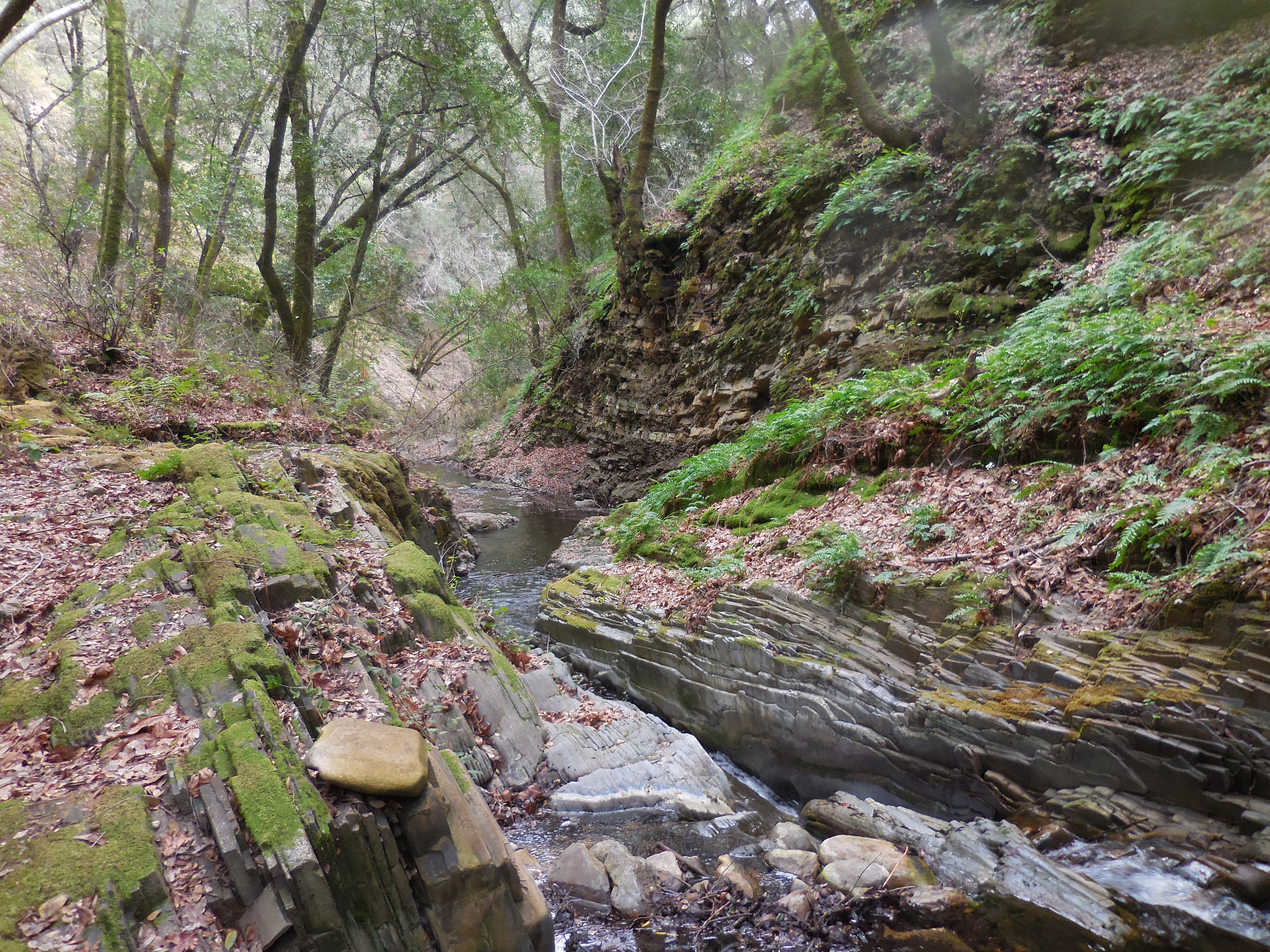
| Camp Description: | This camp is located in a very nice tree shaded slot canyon with flowing water right below it. Â It features a picnic table, fire ring and several spots for tents. Â Although it is only a short distance from the Suphur Pots camp it offers a nice alternative if that camp is full. Â Recent work on the Lopez Canyon Trail has made this a nice place for a short overnight backpacking trip. |
| Water Source: | Flowing |
| Water Source Details: | Nice flowing water in the creek |
| Weather Conditions: | Partly Cloudy, cool, high 60's |
| Images: | Camp overview Lopez Canyon water slide |
 Survey / Report Form