 Use Marker Groups
 Wolf 2002
Piru 2003
Day 2006
Zaca 2007
Gap 2008
La Brea 2009

| Date | Surveyor | Water Report |
| 09-02-2023 | AR | Flowing |
| 06-21-2023 | Anonymous | Flowing |
| 05-29-2023 | Anonymous Surveyor | Dry |
| 05-07-2022 | Anonymous Surveyor | Dry |
| 11-27-2020 | Dan Whelan | Dry |
| 03-01-2020 | Antonio Calderon | Dry |
| 03-09-2019 | Christopher P. Lord | Dry |
| 08-11-2017 | Eldon Walker | Dry |
| 05-20-2017 | Craig R. Carey | Dry |
| 01-08-2017 | Josh Lee Pasholk | Dry |
| 11-08-2015 | Los Padres Forest Association | Trickle |
| 05-15-2015 | Craig R. Carey | Flowing |
| 01-18-2015 | Los Padres Forest Association | Trickle |
| 12-06-2014 | Los Padres Forest Association | Dry |
| 10-01-2014 | Los Padres Forest Association | Dry |
The Forest Service established a tree nursery here. Both the 1932 Matilija fire and the 1948 Wheeler fire burned the trees planted by the Forest Service. The Thatcher School students have replanted the present pines. Other trees were lost in the 1985 Wheeler fire but the majority remain.
Located on the Horn Canyon Trail (27W08). This trail was one of the major trails from Ojai to the Sespe River in the early days. It was often used by campers, fisherman and hunters.
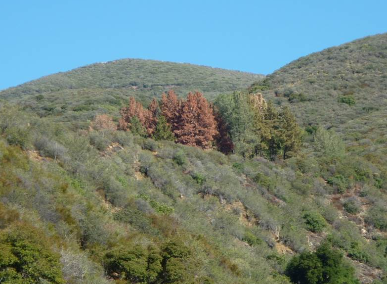
The Pines Camp is set amongst an interesting clump of pine trees. Many of the pines have died during the drought of the mid 2010's and as a result the green clump looks a bit more brown these days. The camp is accessed via the Horn Canyon Trail from Thacher School. The camp is a lovely place to watch the Ojai lights flicker through the orangish red of a sunset but is most commonly visited as a dayhike.
Northeast of Ojai via State Highway 150, Reeves Road, and McAndrews Road (5N10) to the locked gate behind Thacher School. At this point a narrow, the steep Horn Canyon Trail (27W08) leads uphill for about 3 miles to the Pines Camp.


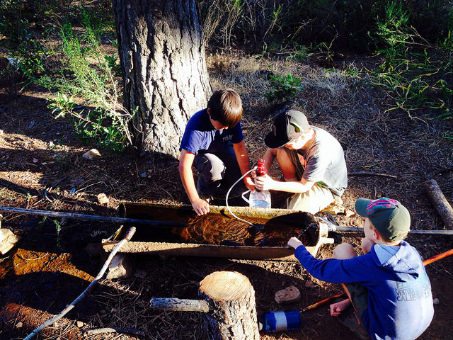
 The Pines Camp Survey - 09-02-2023 - by AR
| Link: | The Pines Camp |
| Date: | 09-02-2023 |
| Surveyor Name: | AR |
| Camp Description: | The creek was flowing at an estimated 1.5 CFS, clear and cool. The pipe system for the water source in camp was non-functional, but the creek is still accessible by a steep bank up behind the camp. The sites are getting grown in with mustard and shrubs after the rain this year. Everything was looking green and well hydrated. |
| Water Source: | Flowing |
| Water Source Details: | The creek was flowing at an estimated 1.5 CFS, camp water source non-functional |
| Weather Conditions: | 70s, foggy and drizzly |
The Pines Camp Survey - 06-21-2023 - by Anonymous| Link: | The Pines Camp |
| Date: | 06-21-2023 |
| Surveyor Name: | Anonymous |
| Camp Description: | Not a lot of shade. Seats, etc. shown in pictures from years prior all gone (likely burned). Thanks to whoever left the rope to help get down to the little creek! |
| Water Source: | Flowing |
| Water Source Details: | Water plentiful in the creek behind camp - found by following a use trail from an unattached spigot up then back down into the creek ravine. |
| Weather Conditions: | Sunny and warm daytime; chilly overnight |
The Pines Camp Survey - 05-29-2023 - by Anonymous Surveyor| Link: | The Pines Camp |
| Date: | 05-29-2023 |
| Surveyor Name: | Anonymous Surveyor |
| Camp Description: | The campsite spigot has no water. No run off waterfalls or creeks to campsite. The only water is the beginning of Thacher trail with three river crossings that are easily passable. There are few dirt flat areas to place tent but majority is pressed down vegetation. Very exposed to sun. There are few down tree trunks to sit. Trail is maintained with beautiful wildflowers. |
| Water Source: | Dry |
| Water Source Details: | |
| Weather Conditions: |
The Pines Camp Survey - 05-07-2022 - by Anonymous Surveyor| Link: | The Pines Camp |
| Date: | 05-07-2022 |
| Surveyor Name: | Anonymous Surveyor |
| Camp Description: | With all the regeneration after the Thomas Fire in
2017, it's reverting to wild land that won't be usable at all in a short
time. The camp is completely overgrown, in very poor shape,
and should no longer be considered or advertised as a camp. |
| Water Source: | Dry |
| Water Source Details: | |
| Weather Conditions: |
The Pines Camp Survey - 11-27-2020 - by Dan Whelan| Link: | The Pines Camp |
| Date: | 11-27-2020 |
| Surveyor Name: | Dan Whelan |
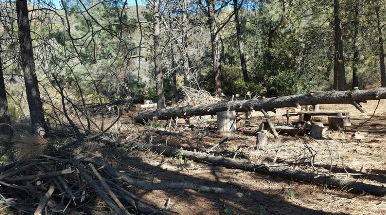
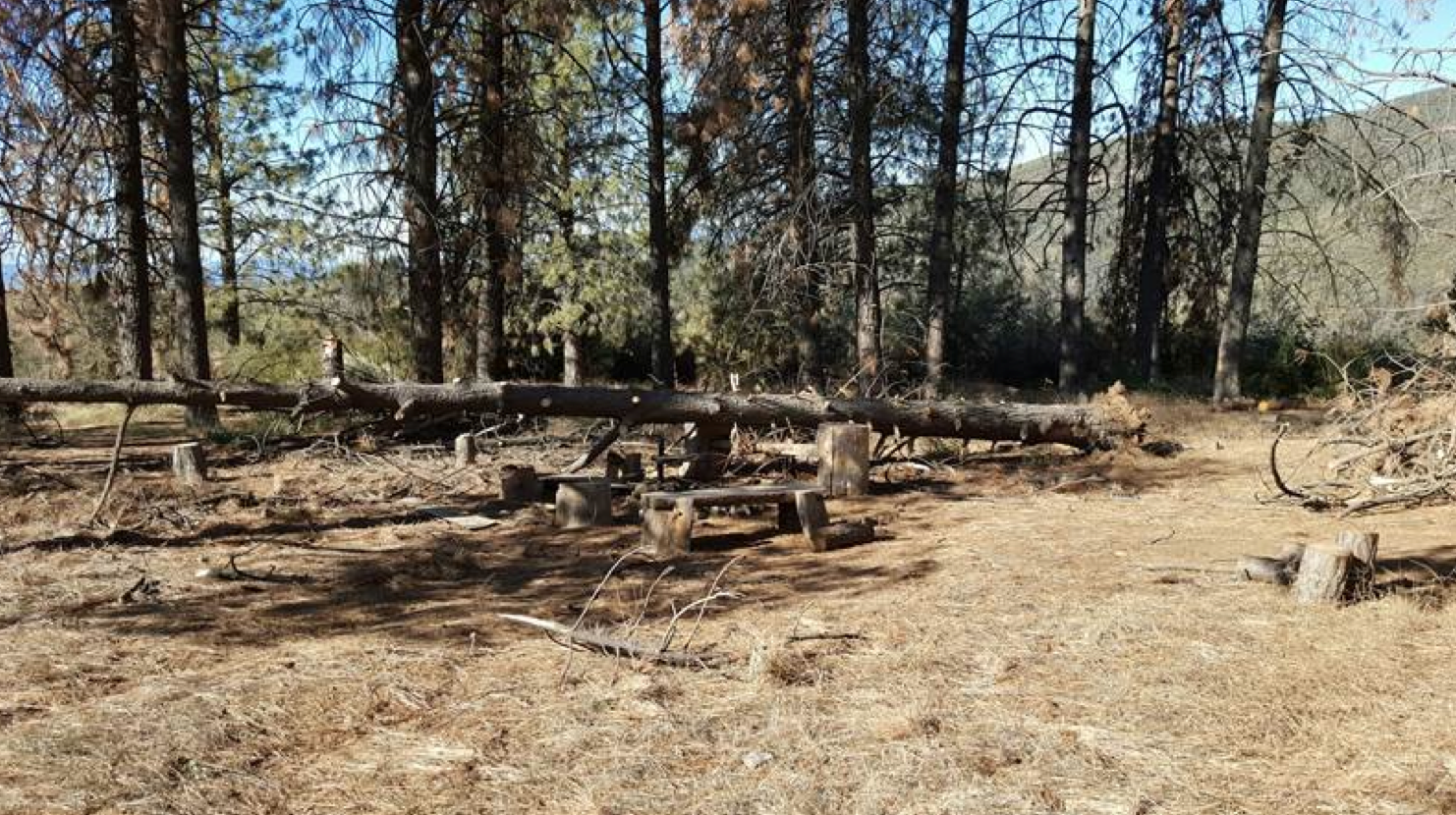
| Camp Description: | This camp looks like it has been abandoned by the Forest Service. There remain only seven trees living in one close cluster. Four dead trees are standing and many trees are downed in the camp ground. The entire camp is chocked in brush and annual growth. The camp needs a major overhaul, something I doubt Los Padres will ever do. |
| Water Source: | Dry |
| Water Source Details: | na |
| Weather Conditions: | clear, low 60s |
The Pines Camp Survey - 03-01-2020 - by Antonio Calderon| Link: | The Pines Camp |
| Date: | 03-01-2020 |
| Surveyor Name: | Antonio Calderon |
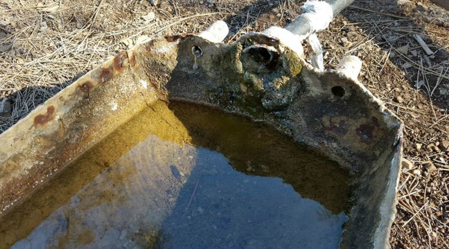
| Camp Description: | Shrubs and bush continue  to encroach the camp. |
| Water Source: | Dry |
| Water Source Details: | |
| Weather Conditions: | Low 50s, foggy with a drizzle |
| Images: | Pines Camp Dry trough |
The Pines Camp Survey - 03-09-2019 - by Christopher P. Lord| Link: | The Pines Camp |
| Date: | 03-09-2019 |
| Surveyor Name: | Christopher P. Lord |
| Camp Description: | Horn Canyon trail leading into Camp is in great shape wish the same could be said about The Pines. Trough was dry and the spring piping seems to be no longer viable. While Thatcher Creek is flowing nicely it is not easily accessed from Camp. The combo of Bark Beetles, Fire and previous droughts have all but destroyed the once beautiful trees. Brushing is badly needed around camp. Watch out where you place your tent. Due to it's prime location Rehab here should be at the top of list. More details can be found from the link below. https://christopherplord.blogspot.com/2019/03/chief-peak-by-way-of-horn-canyon.html |
| Water Source: | Dry |
| Water Source Details: | |
| Weather Conditions: | |
| Images: | |
The Pines Camp Survey - 08-11-2017 - by Eldon Walker| Link: | The Pines Camp |
| Date: | 08-11-2017 |
| Surveyor Name: | Eldon Walker |
| Camp Description: | I have 50 years experience visiting The Pines camp and approximately 40 years worth of pictures. One can fairly say that The Pines camp no longer exists in a recognizable form as The Pines due to drought and bark beetle infestation. |
| Water Source: | Dry |
| Water Source Details: | |
| Weather Conditions: | Hot, 90 degrees + and dry on August 11, 2017. |
| Images: | The Pines camp, panoramas: pre-drought (upper) and August 11, 2017 (current state). |
The Pines Camp Survey - 05-20-2017 - by Craig R. Carey| Link: | The Pines Camp |
| Date: | 05-20-2017 |
| Surveyor Name: | Craig R. Carey |
| Camp Description: | As part of their 16-mile trek from Piedra Blanca TH to Thacher School, the intrepid mountain men of Troop 111 (Ventura) took a break at The Pines on Saturday 5/20. Sad to see the camp as it is now. Site should be cleared of grass before any campfires. |
| Water Source: | Dry |
| Water Source Details: | |
| Weather Conditions: | Hot and dry. |
| Images: | |
The Pines Camp Survey - 01-08-2017 - by Josh Lee Pasholk| Link: | The Pines Camp |
| Date: | 01-08-2017 |
| Surveyor Name: | Josh Lee Pasholk |
| Camp Description: | Hiked up here on a Sunday after it rained. Plenty of people hiking on the trail but only a few made it up to the camp. All but a few of the pine trees have been cut down due to the hazardous nature of standing dead trees in a place where people frequent. It's a sad sight as it was a really nice little getaway just outside Ojai, which is a getaway in and of itself. I wouldn't recommend camping here as you now have to pack in all of your own water, and at 8 pounds a gallon be my guest. If you'd like to check out some more pictures, take a look at my blog! I plan to post at least one hike a month if not more. |
| Water Source: | Dry |
| Water Source Details: | Spring wasn't flowing, sitting rainwater in trough stagnant |
| Weather Conditions: | Cloudy 55 |
| Images: | |
The Pines Camp Survey - 11-08-2015 - by Los Padres Forest Association| Link: | The Pines Camp |
| Date: | 11-08-2015 |
| Surveyor Name: | Los Padres Forest Association |
| Camp Description: | Report from Ranger Heidi: - Water flowing at the horse trough at The Pines - 23 pines that appear dead and standing at the camp - Three trees have fallen recently in the camp CAMPING AT THE PINES IS STRONGLY DISCOURAGED |
| Water Source: | Trickle |
| Water Source Details: | |
| Weather Conditions: | |
| Images: | Photo Ranger Heidi Photo Ranger Heidi Photo Ranger Heidi |
The Pines Camp Survey - 05-15-2015 - by Craig R. Carey| Link: | The Pines Camp |
| Date: | 05-15-2015 |
| Surveyor Name: | Craig R. Carey |
| Camp Description: | Trees continue to decline; nearly 2/3 of the Coulters are dead or dying. Sad times. Lots of weed and undergrowth starting to encroach; otherwise site is in good shape. Trail getting a tad brushy on some of the switchbacks up, but nothing serious. |
| Water Source: | Flowing |
| Water Source Details: | Recently routered and re-connected by the Thacher students under Headmaster Mulligan's direction, the trough and the adjacent overflow basins are all full. |
| Weather Conditions: | Late-afternoon and night Hike. Clear, cool, and breezy. |
The Pines Camp Survey - 01-18-2015 - by Los Padres Forest Association| Link: | The Pines Camp |
| Date: | 01-18-2015 |
| Surveyor Name: | Los Padres Forest Association |
| Camp Description: | |
| Water Source: | Trickle |
| Water Source Details: | |
| Weather Conditions: |
The Pines Camp Survey - 12-06-2014 - by Los Padres Forest Association| Link: | The Pines Camp |
| Date: | 12-06-2014 |
| Surveyor Name: | Los Padres Forest Association |
| Camp Description: | As reported by Ranger Heidi of the Ojai District. Â No water at The PInes. Â There was water lower on Horn Canyon. Â Camp is clean, the trail has been worked and sadly many of the pines are dying from the drought. |
| Water Source: | Dry |
| Water Source Details: | |
| Weather Conditions: | |
| Images: | Photo, Ranger Heidi |
The Pines Camp Survey - 10-01-2014 - by Los Padres Forest Association| Link: | The Pines Camp |
| Date: | 10-01-2014 |
| Surveyor Name: | Los Padres Forest Association |
| Camp Description: | Information from the Ojai Ranger District |
| Water Source: | Dry |
| Water Source Details: | Only water at second crossing from bottom |
| Weather Conditions: |
 Survey / Report Form