 Use Marker Groups
 Wolf 2002
Piru 2003
Day 2006
Zaca 2007
Gap 2008
La Brea 2009

| Date | Surveyor | Water Report |
| 11-24-2020 | Anonymous Surveyor | Flowing |
| 04-20-2019 | Christopher P. Lord | Flowing |
| 03-24-2019 | Christopher P. Lord | Flowing |
| 01-18-2016 | JO | Trickle |
Not to be confused with the Last Chance Camp in the Ventana Wilderness, this seldom visited site was abandoned by the Forest Service in the early 1970's and, according to Gagnon, was once slated for removal. Contrary to many of the former Los Padres recreation maps and various Quads, the camp actually resides on the southern side of The Last Chance Trail 21W09 along the western bank of Upper Santa Paula Creek. The Camp provides excellent views down-canyon and up towards Hines Peak, as well as the southern flank of the Topatopa Mountains. The Last Chance Trail receives little to no maintenance and can be difficult to follow, especially coming up from new trailhead at Thomas Aquinas, with much of the trail non existent after Jackson Hole. A slightly easier option would be to start atop Nordhoff Ridge and follow the Red Reef Trail, then drop in from the old Last Chance connector 21W20. No official signs will mark this path and travel here should be reserved for the more experienced backcountry wanderer seeking solitude and a true wilderness experience.


 Last Chance Camp - Sespe Survey - 11-24-2020 - by Anonymous Surveyor
| Link: | Last Chance Camp - Sespe |
| Date: | 11-24-2020 |
| Surveyor Name: | Anonymous Surveyor |
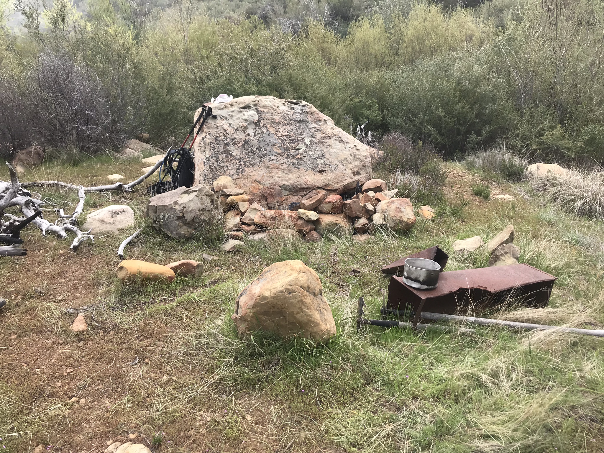
| Camp Description: | Creek was flowing right next to camp. Looks like no one has stayed here in quite a while. Grass is starting to take over. Just a big Boulder with fire ring and some old tools laying around. Great view of Hines peak. |
| Water Source: | Flowing |
| Water Source Details: | |
| Weather Conditions: | Sunny 70F |
| Images: | Last Chance camp Hines peak from camp |
Last Chance Camp - Sespe Survey - 04-20-2019 - by Christopher P. Lord| Link: | Last Chance Camp - Sespe |
| Date: | 04-20-2019 |
| Surveyor Name: | Christopher P. Lord |
| Camp Description: | This is an update to my recent Camp survey from March. Apparently I had missed the original Main Camp site by less than a hundred feet. I previously detailed what I now feel were overflow or guerrilla sites very near the main site. Original FS Camp can be found here at these coordinates :  N34° 29' 49.1" W119° 03' 20.4" Camp has large rock fire ring, an old weathered ice can stove, a pair of McLeod tools and new site register can with a $25 dollar REI gift card I left for the next visitor to enjoy. (Please see photographs attached with this report). Water was available from the creek that sits about 25 feet from the Site. 21W09 is no longer maintained and good route finding skills are required to access the camp from lower Santa Paula Canyon. A more detailed report of the days events can be found at the link below: |
| Water Source: | Flowing |
| Water Source Details: | |
| Weather Conditions: | Low 60's and Foggy |
| Images: | Main Camp overview New Site Register can Can lies hidden under the boulder Creek flowing near camp another view of the main site |
Last Chance Camp - Sespe Survey - 03-24-2019 - by Christopher P. Lord| Link: | Last Chance Camp - Sespe |
| Date: | 03-24-2019 |
| Surveyor Name: | Christopher P. Lord |
| Camp Description: | As I understand it this camp has been associated with 2 different sites over the years. What I have labeled Last Chance Camp site #2 (which is the same one listed here on HLP website can be found at this location) - N34.49741° W119.05512° Not much remains here beside a very small rock fire ring. Water was flowing on Sunday from the seasonal Creek that runs alongside the camp. Last Chance Camp site #1 can be found .2 mile south of the above location - N34.49480° W119.05435°. Here 2 creeks converge a mere feet from the camp and provide a really neat small seasonal water fall. Both streams were flowing nicely during my visit. One rock fire ring remains fully intact and a few small pieces of the old stove can be found. The flat is roomy enough for multiple tents. Both sites lack any trees to provide shade. The camp and trail leading in have been abandoned for decades so being familiar with off trail adventure and route finding skills will help tremendously should you attempt a visit. For more details on my recent trip you can visit my blog link below. I have attached relevant pictures with this report. |
| Water Source: | Flowing |
| Water Source Details: | |
| Weather Conditions: | |
| Images: | Fire ring and stove parts site #1 Waterfall Site #1 flat area site #1 fire ring site #2 Creek along site #2 |
Last Chance Camp - Sespe Survey - 01-18-2016 - by JO| Link: | Last Chance Camp - Sespe |
| Date: | 01-18-2016 |
| Surveyor Name: | JO |
| Camp Description: | Not much here. Â An old stove. Â Fire pit has been filled in with rocks. Â Water flow is a trickle, but can be collected. Â Trail is rough. |
| Water Source: | Trickle |
| Water Source Details: | very low flow of water but can be collected |
| Weather Conditions: | 25 yards visibility, cold, rainy |
| Images: | thin trickle of water old stove poor visibility, couldn't see much terrain or landmarks. Hard to read map without seeing land details. |
 Survey / Report Form